News
Flash Flood Watch Issued for Los Angeles Ahead of Heavy Rainfall
LOS ANGELES, California — The National Weather Service (NWS) has issued a Flash Flood Watch for much of Los Angeles, effective from 1:00 PM local time on February 13 through 4:00 AM on February 14, 2025, as an atmospheric river nears the region. This advisory includes areas with recent burn scars, where debris flows and catastrophic flooding are concerns.
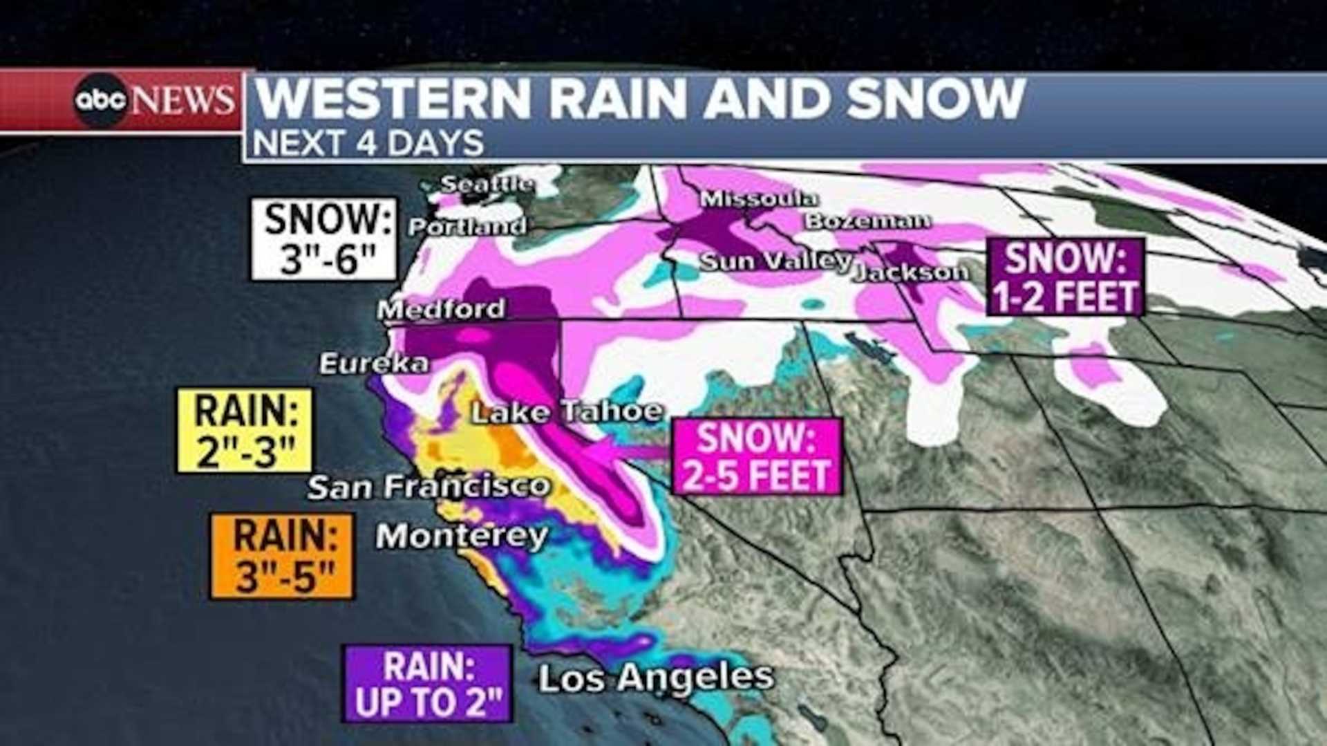
The atmospheric river is expected to bring substantial rainfall, with totals forecasted to reach between 75 mm and 150 mm (3 to 6 inches) in the Sierra Nevada and Central California Coast Ranges. Southern California’s lower elevations could see precipitation totals of about 50 mm to 100 mm (2 to 4 inches), while certain isolated areas may experience more than 250 mm (10 inches), according to the Weather Prediction Center.
Residents are urged to modify travel plans and avoid roads, streams, and rivers as heavy rain could lead to swift-water rescues and urban flooding. With widespread warnings in effect, officials are particularly cautious about potential flooding on roadways.
“This event could bring an increased risk of power outages, flooding in small streams, and debris flows on roadways,” a spokesperson for NWS stated. Authorities are mobilizing to improve response readiness, deploying emergency services across affected areas.
The heaviest downpours are anticipated late Thursday into Friday, potentially impacting urban and burn scar locations the most. The Center for Western Weather and Water Extremes emphasizes that significant impacts from the storm could occur within a 24-hour window.
Snowfall in the Sierra Nevada could exceed 1.2 m (4 feet), raising the likelihood of hazardous winter conditions. The Weather Severity Index indicates over an 80% probability of major winter storm effects in Central and Southern Sierra Nevada, with high winds compounding adverse conditions.
Due to concerns about flooding in fire-damaged regions, officials are escalating precautions and have issued evacuation warnings in Santa Barbara, Los Angeles, and Ventura counties. Local authorities advise residents to prepare “go-bags” and to be familiar with evacuation routes in light of the predicted mudslide risks.
“We have city departments on high alert as rain approaches LA,” said Los Angeles Mayor Karen Bass in a statement on social media. Evacuation orders are set to take effect from 7 AM on February 13 until 2 PM on February 14 in specific areas prone to mudslides.
In Orange County, voluntary evacuation warnings have been issued for residents in the Airport Fire burn area, while numerous communities near the Line Fire burn scar remain under alert for mudslides.
This latest atmospheric river follows a series of storms that recently engulfed Northern California, resulting in record rainfall, major floods, and property damage. The California-Nevada Forecast Center has warned of additional rainfall exacerbating already elevated streamflow levels across the Sacramento Valley.
The situation is dynamic, and authorities are monitoring conditions closely. Emergency shelters are being set up to accommodate those in need, especially in regions under threat from severe winter weather.


