News
Severe Storms Brace Bay Area: Wind and Rain Expected
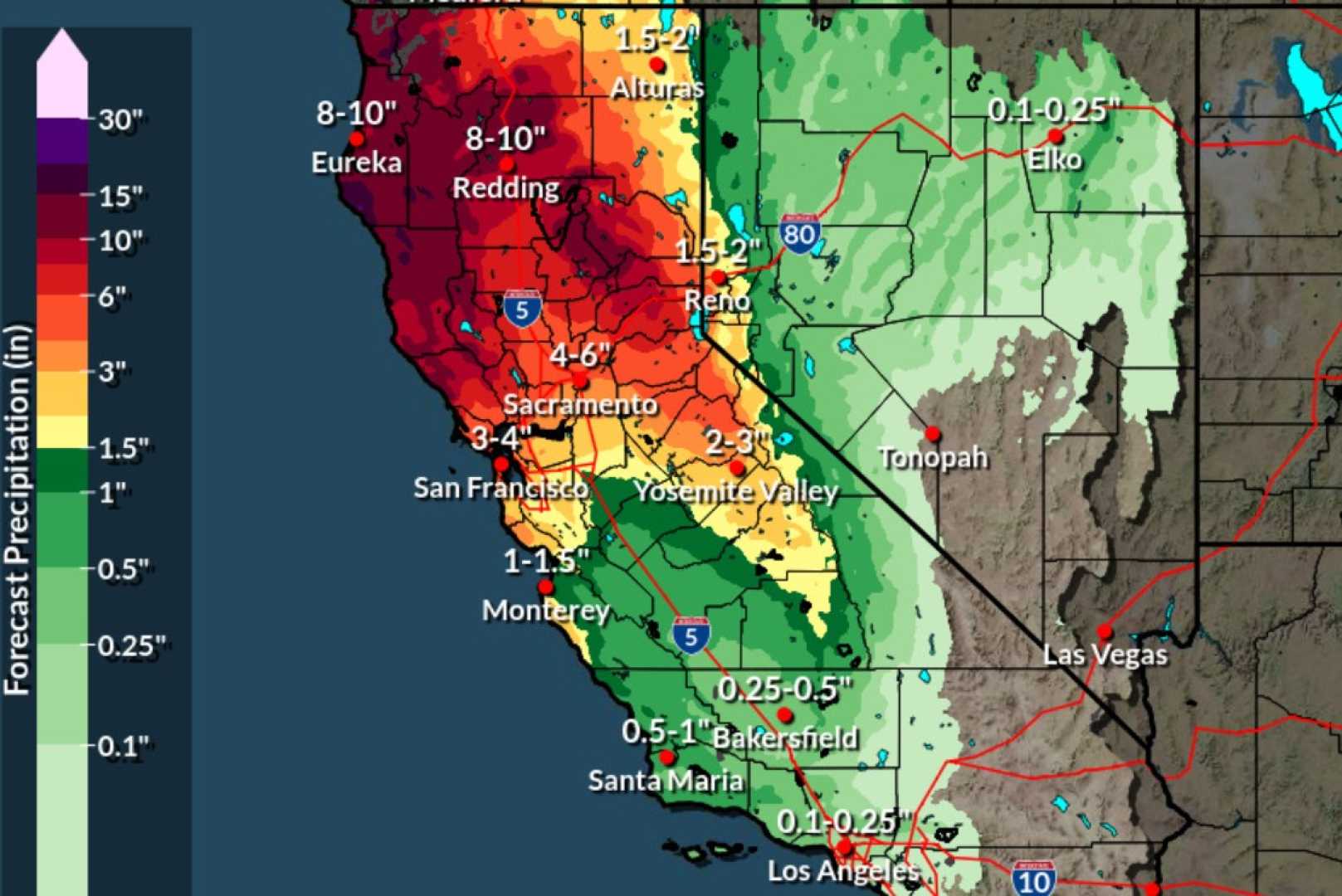
SAN FRANCISCO, Calif. — A series of powerful storms is set to impact the Bay Area starting today, with heavy rain and gusty winds expected to sweep across the region. The National Weather Service has issued a Wind Advisory and a Winter Storm Warning in preparation for the adverse weather conditions.
The rain will make its initial appearance in the North Bay this afternoon, progressing southward toward the Peninsula, East Bay, and Santa Clara Valley as the day unfolds. Meteorologist Spencer Christian from ABC7 forecasts increased rainfall during the evening hours, classifying the storm as a one on the exclusive ABC7 Storm Impact Scale, with gusty winds anticipated to accompany the downpour.
Wind advisories for the Bay Area are in effect from 11 a.m. to 11 p.m. tonight in the North Bay and from 5 p.m. to 2 a.m. for the East Bay and Santa Cruz Mountains. Wind gusts of up to 45 mph could lead to downed tree limbs and power outages.
As the storm moves in, it is expected to bring significant snowfall to the Greater Lake Tahoe Area. A Winter Storm Warning is effective from 5 p.m. today until 11 p.m. tomorrow, with snow accumulations projected to reach three feet in mountainous regions. This is particularly critical as Northern California is aiming to boost its snowpack ahead of the spring.
Looking ahead, tomorrow’s weather will include scattered showers throughout the day, with some isolated downpours possible. Although the wind advisory will expire, gusts up to 30 mph may still persist. Partial clearing is expected tomorrow night before a more settled and mild day on Tuesday.
However, the weather activity won’t cease there. Another winter storm is on the horizon, poised to unleash moderate to heavy rain and snow from Wednesday through Thursday, presenting significant impacts for mountain travel.
“This upcoming storm will be stronger and colder than the current system,” Christian said. “We are advising residents to prepare for potentially hazardous conditions.”
The storm system forecasted for later in the week may cause travel disruptions as heavy snow accumulations are expected across the Sierra, with travel being strongly discouraged due to whiteout conditions. Snow levels are anticipated to drop from 6,000-5,000 feet to 2,500-3,000 feet by Thursday morning.
Moreover, with gusts potentially reaching up to 65 mph in the Sierra, chains will likely be required at mountain passes, as snowfall rates could reach two to three inches per hour. Northern California’s snowpack is critically below average, and this storm is expected to play a crucial role in addressing that deficit.
As the first storm clears out Thursday night, a subsequent storm could move in by Friday afternoon, although this system is forecasted to be weaker. Rain and snow will linger into early Saturday, before the sky clears into the weekend.
Residents are urged to stay updated with the latest forecasts as conditions are subject to change. With an unsettled pattern projected, more rain is likely to return as early as next Sunday night.


