News
Severe Weather Threat Looms Over Memphis This Weekend
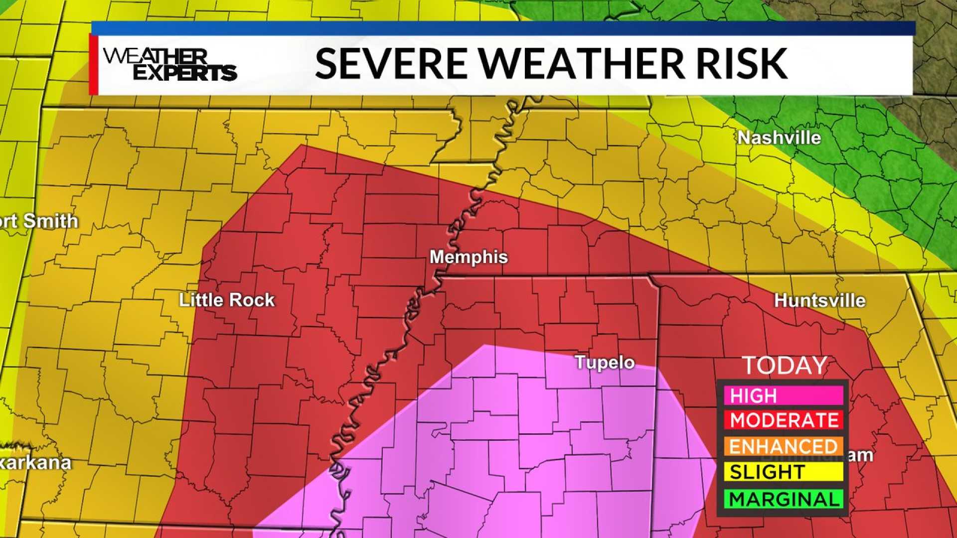
MEMPHIS, Tenn. – A Flood Watch is in effect for Memphis and the Mid-South region from Friday evening until 6 a.m. Sunday, raising concerns about strong to severe storms that may include tornadoes. The National Weather Service cautions residents to stay vigilant as the storms approach.
On Saturday, the area can expect widespread showers and thunderstorms, with temperatures reaching around 70°F. Winds will be from the south at 10-15 mph, gusting up to 30 mph. The most significant threat will occur along and south of Interstate 40, where damaging winds, large hail, and the potential for tornadoes rated EF-2 or stronger are forecasted.
Heavy rains are also anticipated, particularly across northwest Tennessee, where accumulations of 4-6 inches are possible. These conditions significantly heighten the risk of flash flooding.
The storms, exhibiting high levels of storm energy (CAPE), are expected to strengthen across the southern counties by the afternoon and evening hours. Weather experts note that although the forecast pinpoints areas of heightened risk, severe storms could develop anywhere within the region.
“It’s crucial for residents to remain weather aware as conditions can change quickly,” said a spokesperson from the National Weather Service. “The peak of the severe weather threat is anticipated between 1 p.m. and 8 p.m. on Sunday.”
After the storms, temperatures are forecasted to plummet. Tonight, rainfall and thunderstorms will persist until tapering off, with low temperatures around 35°F and southwest winds continuing at 15-20 mph.
A detailed timeline of the upcoming weather conditions indicates a drastic pattern shift beginning Sunday. Following cloudy skies, conditions will clear to mostly sunny, but temperatures will significantly drop to a high near 41°F. By Monday, the forecast predicts a high of 43°F, while Tuesday could see a wintry mix transitioning to snow.
The National Weather Service details further, stating that a 90% chance of snow is possible Tuesday night, with temperatures dropping to around 20°F—creating an environment for accumulating snow. Snow showers could linger into Wednesday.
Residents have been advised to monitor local alerts and exercise caution during travel, especially in areas prone to flooding. “Turn around, don’t drown when encountering flooded roads,” the NWS urged, emphasizing that most flood-related fatalities happen in vehicles.
The severe weather threat aims to serve as a reminder for the Mid-South that conditions associated with storms require preparation and awareness. Weather officials recommend downloading local apps or setting alerts to stay updated on the latest developments.


