Snowfall Impacts North Carolina, Another Storm on the Horizon
WINSTON-SALEM, N.C. — A winter storm brought significant travel impacts to North Carolina and Virginia this week, peaking on the evening of February 19, 2025. This storm marks the latest in a series of winter weather events affecting the region during February, with forecasts indicating another round of snow expected early Thursday.
Snowfall totals varied across the Triad region, with most areas receiving between one to two inches of snow. However, lower accumulations were reported in the Foothills and Piedmont, where many communities saw only a dusting to less than an inch. The parent low pressure system, originating in the Gulf of Mexico, moved too far east to deliver significant snowfall to the western sections of North Carolina.
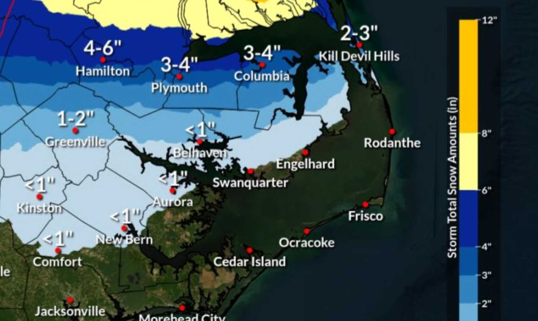
As forecasters tracked the storm, they noted that cold, dry air from Canada had significantly impacted weather patterns across the Midwest and mid-Atlantic, reaching the Carolinas by early Wednesday. The moisture generated from the Gulf storm largely converted into snow in the northern regions including Virginia Beach, which recorded over nine inches of snow.
A Winter Storm Warning was in effect for Rockingham and Caswell counties until 1:00 p.m. Thursday, as these areas appeared poised to receive additional snowfall due to a lingering band of snow showers. Meanwhile, a Winter Weather Advisory covered most counties, including Alamance, Forsyth, and Guilford, and extended into neighboring Virginia.
Weather conditions began to stabilize by midday Wednesday, with radar capturing intermittent snow activity across numerous counties. The snowfall increased in intensity through the late afternoon, especially in the eastern Triad, where a steadier band of snow developed. By evening, snowfall began to taper off, leaving behind residual effects such as slick roads and reduced visibility.
“We’re confident that as the storm pulls away this morning, temperatures will remain very low, which can lead to black ice on roads, especially in shaded areas,” said meteorologist Dylan Hudler. “Travelers should remain cautious, particularly during the morning commute.”
Given the expected weather conditions, officials advised residents to prepare for potential travel difficulties, especially in areas like Guilford, Alamance, and Rockingham counties, where snowfall totals might range between one to three inches. The forecast for Thursday predicts additional snow showers may contribute minimal accumulation, estimated at a few tenths of an inch.
As temperatures continue to hover near freezing, the region may experience hazardous conditions due to refreezing overnight. High winds are also anticipated, with gusts reaching up to 25 mph, further lowering the wind chill.
In the aftermath of the cold front, meteorologists expect conditions to gradually improve throughout the week with a warming trend setting in. “By this weekend, temperatures are likely to climb into the 40s and even 50s by Sunday, providing some relief from the arctic conditions this week,” added Hudler.
Overall, residents are urged to remain vigilant for the remainder of the week while monitoring ongoing weather updates as the situation evolves.