Spring Cold Snap: Freeze Warnings Issued for North Georgia
MARIETTA, Ga. — North Georgia is bracing for a spring cold snap as parts of the region face Freeze Warnings and Frost Advisories early Wednesday morning. The warnings, effective from 2 a.m. to 10 a.m., indicate that temperatures could plummet to near or below freezing in several areas.
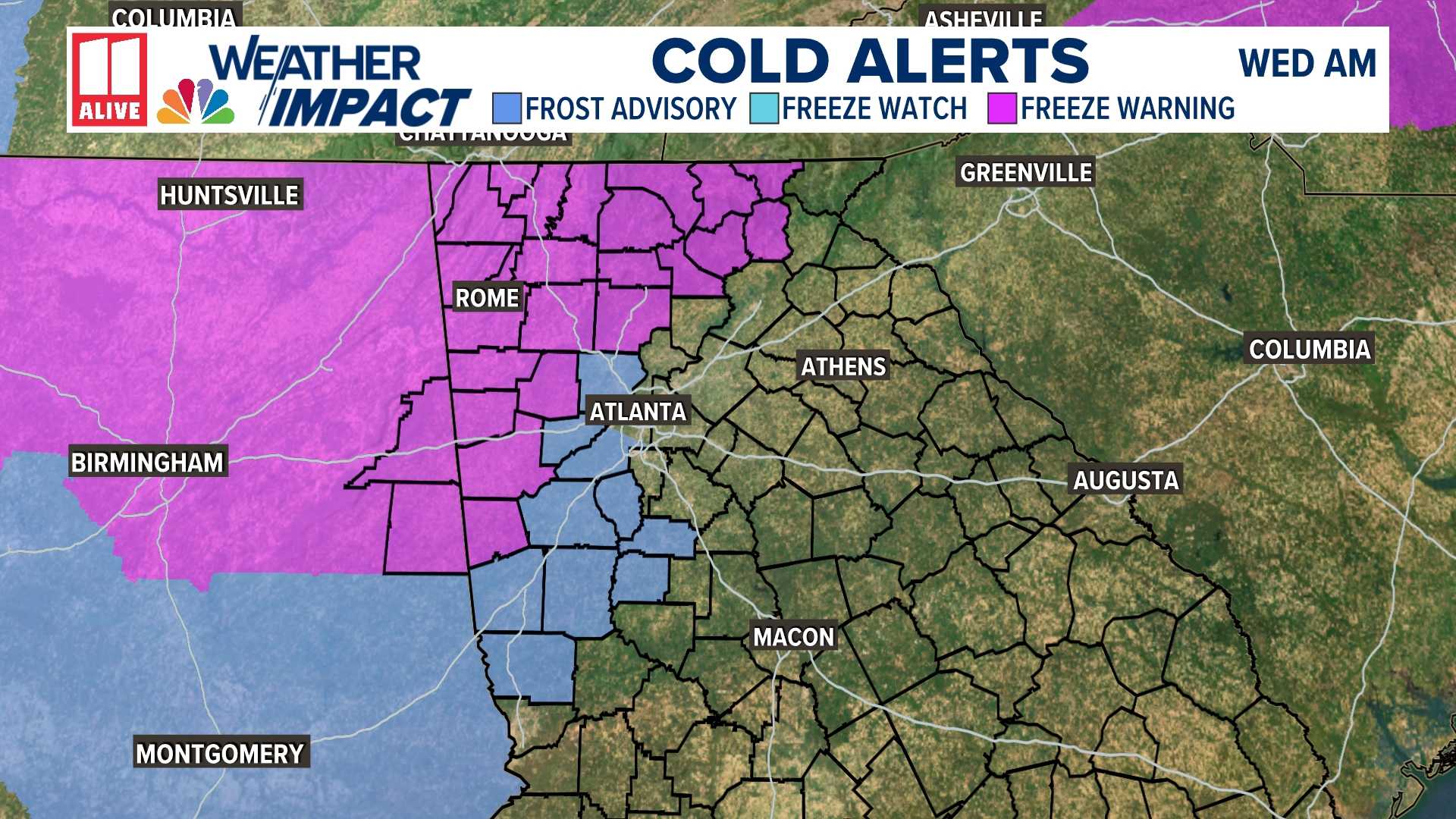
The Freeze Warning, depicted in purple on weather maps, covers far northwest Georgia, where temperatures are expected to hover around 32 degrees. Meanwhile, a Frost Advisory in periwinkle blue applies to the western and southwest sectors of the Atlanta metro area, forecasting lows in the mid-30s.
The conditions necessary for frost formation—clear skies, calm winds, and temperatures dropping to 36 degrees—will be partially met, as a light wind may hamper widespread frost. However, protected valleys could still experience patchy frost by early Wednesday.
To safeguard vulnerable plants from the cold, gardeners are advised to cover them with frost cloths or sheets or to bring potted plants indoors. Such measures will help mitigate potential damage.
This late-season chill is not unprecedented; Atlanta’s average last freeze occurs on March 21, and early April frosts are common in outlying areas. A Freeze Watch, issued Monday afternoon, encompasses regions along and north of Interstate 85, affecting cities including Rome, Dalton, Cartersville, Blairsville, and Carrollton. Forecasted lows in impacted counties may range between 28 and 32 degrees, according to the National Weather Service.
The NWS warned, “Frost and freeze conditions could kill crops, other sensitive vegetation, and possibly damage unprotected outdoor plumbing. Take steps now to protect tender plants from the cold.”
Included counties under this alert are Dade, Walker, Catoosa, Whitfield, Murray, Fannin, Gilmer, Union, Towns, Chattooga, Gordon, Floyd, Bartow, Polk, Paulding, Haralson, Carroll, and Heard. The timeline for the Freeze Watch is consistent, set from 2 a.m. to 10 a.m. Wednesday, affecting northwest, north-central, northeast, and west-central Georgia.
Specific forecasts suggest that in northwest Georgia towns like Trenton and Summerville, temperatures may dip to around 31 degrees, with widespread frost anticipated. Similarly, northern mountain regions might see temperatures drop to 29 degrees.
Conversely, the Atlanta area is projected to remain sunny and dry, with temperatures dipping to a low of 39 degrees Tuesday night, and expected to reach a high of 67 on Wednesday.
Looking ahead, warmer temperatures should return later in the week, although unsettled weather may trigger isolated to scattered thunderstorms across north and central Georgia on Thursday and Friday. Rain chances peak Thursday night, with a 60% likelihood of showers and storms statewide. By the weekend, conditions are anticipated to clear, bringing sunny skies and temperatures reaching the 60s and 70s back to Georgia.
The information in this article is derived from original forecasting by the FOX 5 Storm Team and the National Weather Service.