News
Severe Storms Threaten Oklahoma with Tornadoes and High Winds
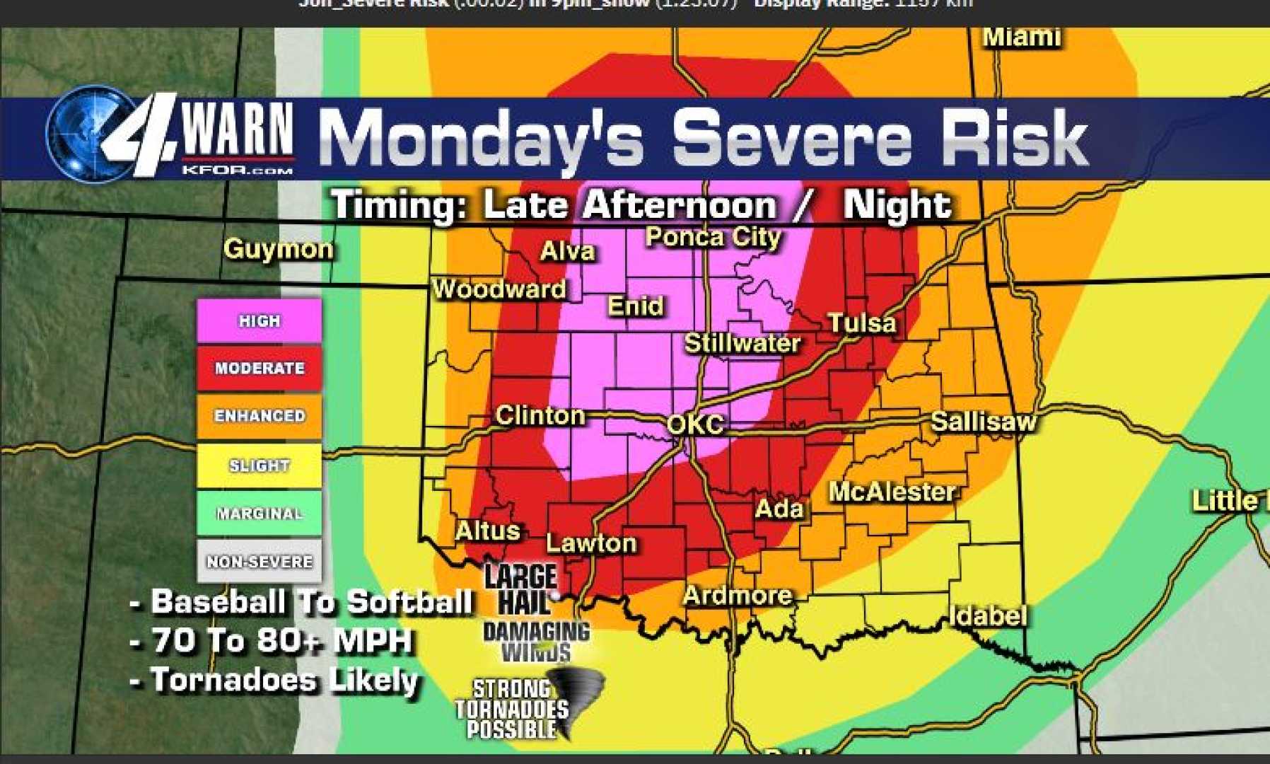
OKLAHOMA CITY, Okla. — Severe storms with a risk of tornadoes and damaging winds are anticipated to move into Oklahoma late Monday night into early Tuesday morning. A tornado watch has been issued for numerous counties until 5 a.m. CST, acknowledging the heightened threat of severe weather.
As of 9:48 p.m. CST, meteorologists reported fast-developing severe thunderstorms across western Oklahoma, traveling eastward at approximately 55 mph. The National Weather Service has warned of potential wind gusts exceeding 60 mph and hail reaching the size of quarters.
“We’re seeing some tremendous lighting displays and the possibility of embedded hail in the storms,” said Michael Armstrong, a field meteorologist stationed in Elk City. “Our main concern tonight will be the strong winds associated with these storms moving into Elk City shortly.”
According to Chief Meteorologist Damon Lane of KOCO 5, storm patterns could create conditions for potential tornadoes overnight, particularly between 1:00 a.m. and 3:00 a.m. “The storm risk is the highest parts of the state have seen since last spring,” he stated.
The tornado watch currently in effect covers a vast area including Alfalfa, Beckham, Blaine, Canadian, Carter, and many other counties. Residents are urged to stay prepared and monitor advisories, especially as storms are expected to impact large urban areas such as Oklahoma City.
The threat for these storms escalated from a preliminary warning earlier in the day as conditions shifted. By 9:35 p.m., a specific severe thunderstorm warning was issued for Major, Woods, and Woodward counties, indicating an ongoing danger due to powerful winds and potential hail.
Safety measures include ensuring storm shelters are clean and stocked with necessary supplies. A local shelter representative recommended preparing essential items like water, snacks, and flashlights. “Be ready for any moisture inside,” they advised.
As conditions evolve, Lane reminds residents to prepare for fast-moving storms. “We could witness brief but intense tornadoes along the leading edge of these storms,” he warned earlier in the day.
In addition to tornadoes, high winds of up to 70 mph and hail may pose risks of significant damage. By 4 p.m. Monday, the tornado index for portions of Oklahoma rated a 6 on a scale of 1 to 10, highlighting an urgent need for vigilance.
As severe weather moves in, News 9 meteorologists continue to provide updates and suggest that individuals download weather apps for real-time alerts tailored to their locations.
With storms expected to clear up by 9:00 a.m. Tuesday, residents are advised to stay alert as high fire dangers may emerge following storm activity due to strong winds.


