News
Severe Thunderstorm Outbreak Looms This Weekend Across Central and Eastern U.S.
CHICAGO, Ill. — A severe outbreak of thunderstorms is forecasted to commence Friday and persist into the weekend, impacting portions of the Midwest, South, and East. The National Oceanic and Atmospheric Administration‘s Storm Prediction Center (NOAA SPC) has raised the risk level to 4 out of 5 for severe weather on both Friday and Saturday, indicating a heightened likelihood of damaging storms capable of producing tornadoes and significant wind gusts.
According to NOAA, areas within the Mississippi Valley, especially near St. Louis, Paducah, Kentucky; Memphis, Tennessee; and Jackson, Mississippi, are particularly vulnerable. The level 4 risk signifies that severe storms are likely to manifest, particularly from Friday afternoon through late night. Residents in these zones should seek shelter as conditions deteriorate.
Storms are expected to initiate on the western edge of the risk area late Friday afternoon, then propagate eastward overnight. Wind gusts between 70 to 90 mph, tornadoes, and large hail are key threats. Kevin Gilmore, a meteorologist with the National Weather Service in New Orleans, highlighted, “It’s going to be later that morning and into the afternoon and evening hours on Saturday where we’re going to likely be seeing a significant severe weather outbreak.”
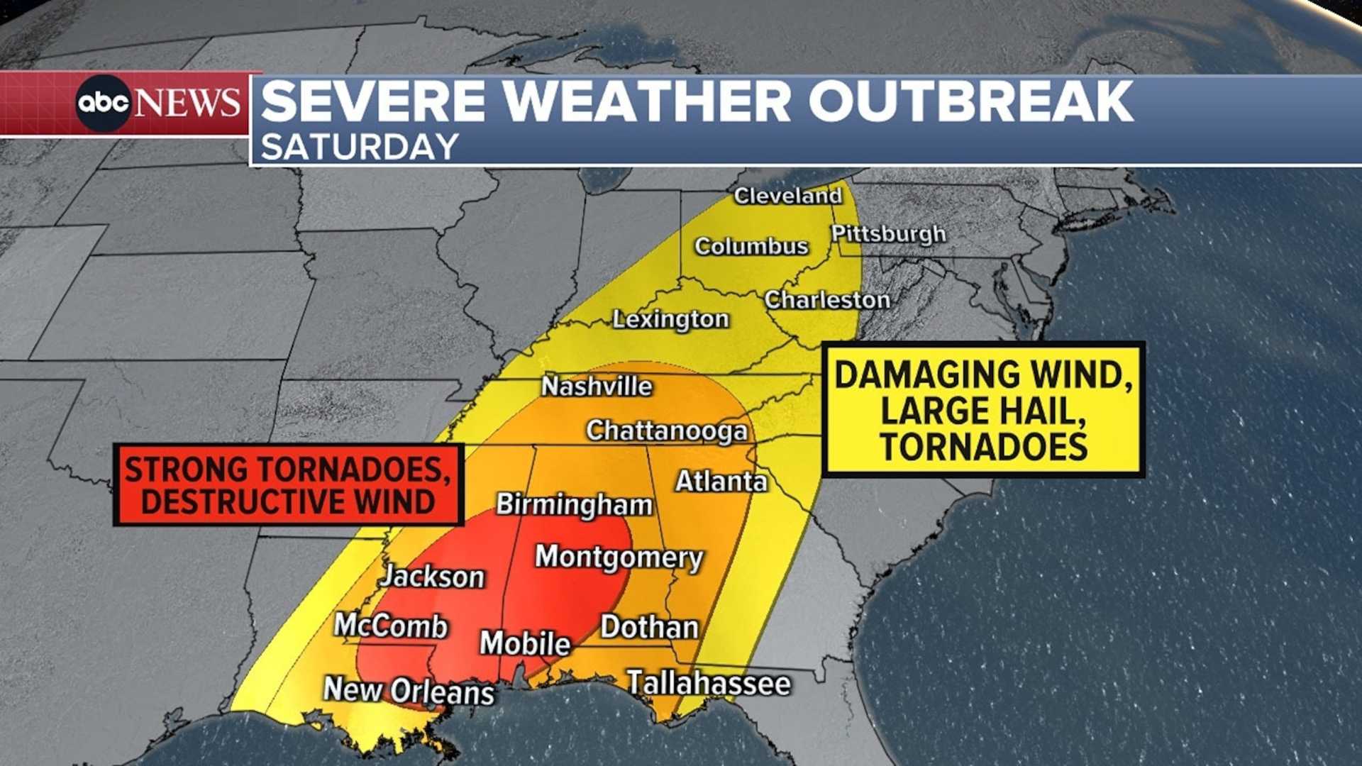
The Deep South, including regions of Alabama, Georgia, Louisiana, Mississippi, and Tennessee, faces the highest likelihood for severe weather. Major cities such as Atlanta, Birmingham, and New Orleans are now under scrutiny as forecasts show a substantial risk for destructive storms on Saturday.
The situation remains highly unpredictable, with threats possibly extending as far north as Ohio and western Pennsylvania by later stages of the weekend. The SPC warns of a “particularly volatile scenario for destructive severe weather” with the possibility of numerous tornadoes rated EF2 or stronger. Flash flooding may also occur across northern Alabama, Mississippi, and parts of Georgia and Tennessee.
As the weekend unfolds, the cold front may generate additional severe storms from the mid-Atlantic states down to the Southeast. Areas like Charleston, South Carolina; Raleigh, North Carolina; and Washington, D.C. could anticipate leftover storm activity, possibly intensifying through the day. Localized flash flooding is also a concern, alongside damaging winds.
The severe weather potential resonates well beyond just the visible storm systems; a complex setup involving a sharp plunge of the jet stream combined with a developing low-pressure system has initiated conducive conditions for storm formation. The influx of moist air from the Gulf of Mexico further supports the possibility of severe thunderstorms capable of rotation.
As Friday approaches, the severe weather risk solidifies across the region, prompting officials to alert millions along the East Coast of potential hazards associated with volatile weather patterns. Altogether, the SPC has alerted more than 14 million people from Mississippi to the Tennessee Valley about the significant risk of severe thunderstorms.
On Friday evening, the threat for the Chicago area intensifies as storm systems sweep across the region. Between 9 p.m. Friday and 3 a.m. Saturday, residents could experience damaging wind gusts and isolated tornadoes. A Wind Advisory has been issued for Cook, DuPage, Will, and several Indiana counties echoed the urgency as forecasters stress caution with these risks.
The National Weather Service has underscored that Saturday will likely see a continuation of this hazardous weather pattern, with communities urged to remain vigilant, particularly as wind advisories remain active. Officials stress preparedness and caution as numerous states brace for the profound consequences of this powerful weather threat.


