News
NASA’s Satellite Captures Complex Tsunami Behavior Following Massive Earthquake
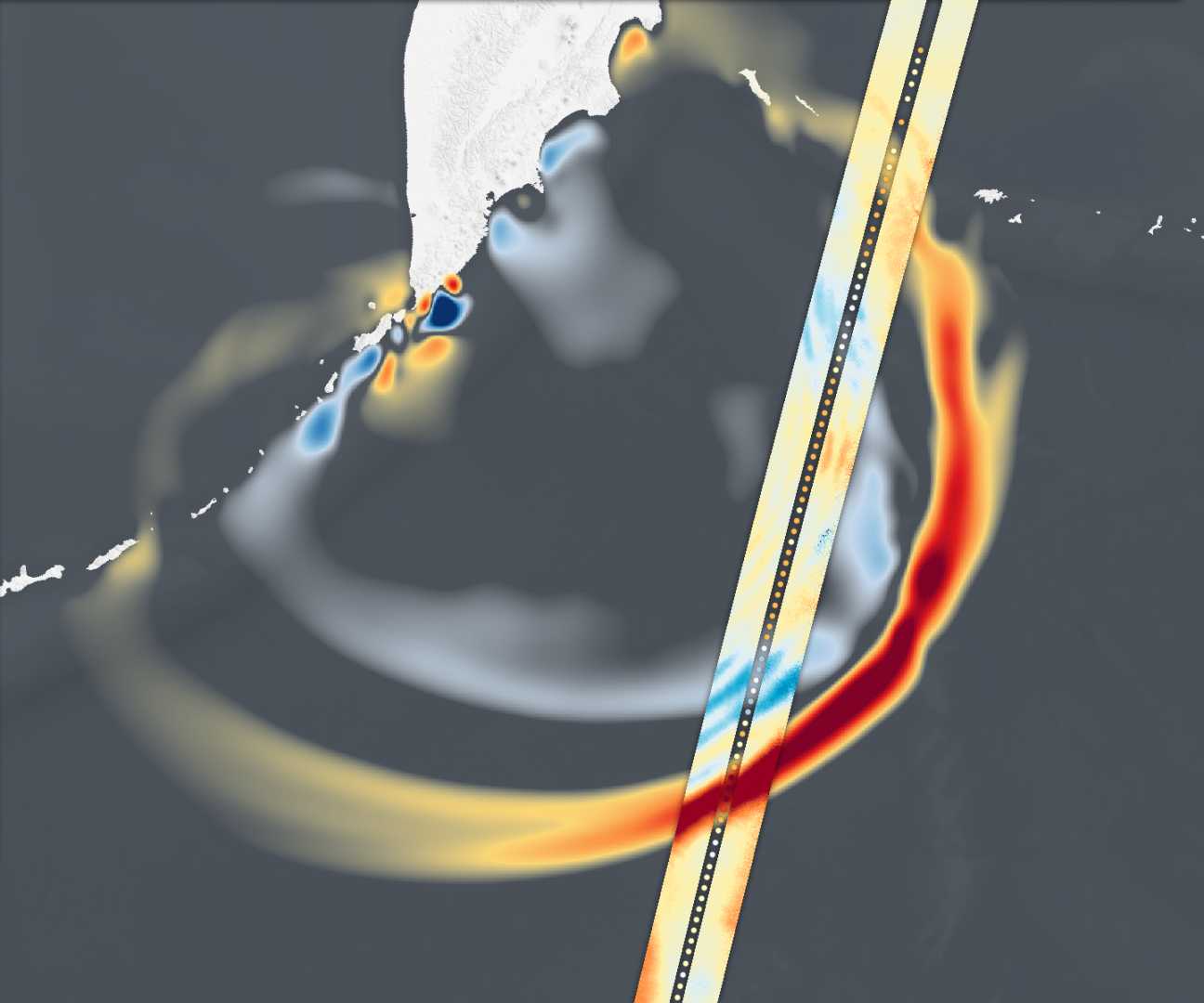
Helsinki, Finland — A magnitude 8.8 earthquake struck the Kuril-Kamchatka subduction zone on July 29, 2025, generating a tsunami that the Surface Water and Ocean Topography (SWOT) satellite captured in unprecedented detail. This event marked the first time that a major tsunami was observed with high-resolution satellite imagery.
The image from SWOT revealed a complex, braided pattern of wave energy, contrary to previous assumptions that larger tsunamis travel as non-dispersive packets. Traditional methods, such as deep-ocean buoys, provided limited insights, capturing data at isolated points.
“I think of SWOT data as a new pair of glasses,” said Angel Ruiz-Angulo, lead author from the University of Iceland. “Before, we could only see the tsunami at specific points in the vastness of the ocean.” SWOT’s ability to map a 75-mile-wide swath of sea surface height allowed scientists to analyze the tsunami’s geometry over time.
Researchers discovered that this tsunami broke apart as it traveled, forming a leading wave followed by smaller trailing waves. The breakthrough indicated that existing tsunami models may need updating to incorporate wave dispersion, which could significantly influence predictions of coastal impacts.
“This extra variability could mean that the main wave might be influenced by trailing waves as it approaches land,” Ruiz-Angulo explained. The findings highlighted that the energy dynamics of tsunamis could be more complex than previously understood.
Data from SWOT complemented information from DART buoys, which recorded the arrival times of the tsunami waves. Two DART stations showed discrepancies in their predictions; one detected waves earlier than anticipated, while another recorded them later. This led to revisions in the earthquake rupture model, suggesting it extended approximately 400 kilometers instead of the initially assumed 300 kilometers.
“The fusion of data from different sources provides a clearer picture of tsunami events,” said co-author Diego Melgar from the University of Oregon. “We are beginning to understand how different data streams can improve tsunami models.”
The Kuril-Kamchatka region has a history of generating large tsunamis, and the 2025 event has important implications for future tsunami forecasting and hazard assessment. The successful use of SWOT may enhance real-time forecasting capabilities, potentially saving lives in coastal areas at risk from tsunamis.
Researchers are optimistic that ongoing SWOT observations will further refine models and provide critical insights into tsunami behavior. The findings were published in a recent study, emphasizing the need for upgraded tsunami forecasting systems capable of incorporating complex data.


