Severe Thunderstorm Warning Issued for Western Washington as Warm Air Moves In
SEATTLE, Wash. — Severe thunderstorms are likely to impact western Washington on Wednesday afternoon and into the evening, prompted by an unstable air mass moving across the region, according to the National Weather Service (NWS).
While temperatures are expected to be slightly lower than the record highs seen on Tuesday, they will remain unseasonably warm, reaching the mid-60s. A cold front approaching from the west is expected to create ideal conditions for thunderstorms, with the potential for hail, gusty winds, cloud-to-ground lightning, and heavy rainfall.
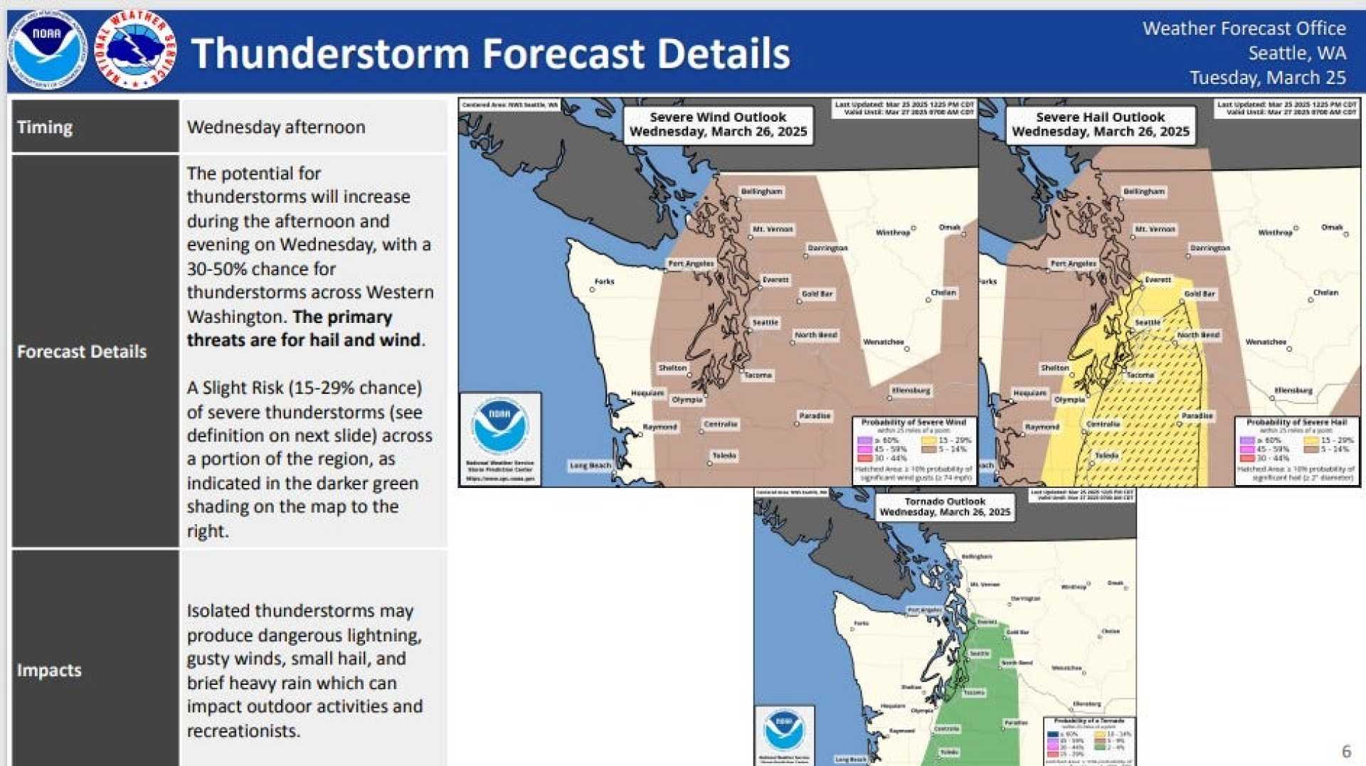
The NWS has issued a “marginal risk” for severe weather throughout western Washington, indicating the possibility of isolated severe storms. The forecast predicts a 15–29% chance of severe hail exceeding one inch in diameter along the I-5 corridor, which extends from Everett south down into Oregon. There’s a potential 10% chance of hail reaching two inches in diameter in the same area, while other regions may see a 5% chance of hail at least one inch in diameter.
Additionally, the NWS indicates a 14% chance of severe wind gusts exceeding 58 mph across large parts of western Washington. A tornado risk remains low, with a 2–4% chance primarily along the I-5 corridor.
Thunderstorms are forecasted to start around 4 p.m. and may persist until approximately 10 p.m. local time. The National Oceanic and Atmospheric Administration (NOAA) confirms that all necessary conditions for thunderstorm formation—moisture, unstable air, and an upward nudge to lift the air—will be present.
In contrast to typical Pacific Northwest weather patterns, experts warn that conditions may be ripe for powerful storm systems. “This is an unusual weather pattern for our area,” said Matt Zaffino, a meteorologist with the NWS. “We’re monitoring the situation closely.”
The typical process for thunderstorm formation starts with warm air, which carries moisture that cools as it rises. As the air ascends, it can create conditions for lightning and thunder, stemming from collisions of ice particles within clouds.
Residents have been advised to prepare for severe weather conditions as they return home during the evening commute, with the potential for localized flooding due to heavy rainfall. By late Wednesday into Thursday morning, expected changes in weather patterns may lead to a transition from storms to light showers.
The system is expected to cool temperatures significantly, dropping to the mid-50s for the remainder of the week. Forecasters suggest that the weather may clear somewhat for the following weekend, allowing for drier conditions across Seattle.