Severe Weather Impacts Southeast Louisiana Today: Tornado Risk Heightens
BATON ROUGE, La. — A significant risk of severe weather is forecasted across southeast Louisiana on Saturday, with conditions expected to worsen between noon and 6 p.m. A level 4 moderate risk has been issued for several parishes, suggesting that scattered to numerous severe thunderstorms are likely.
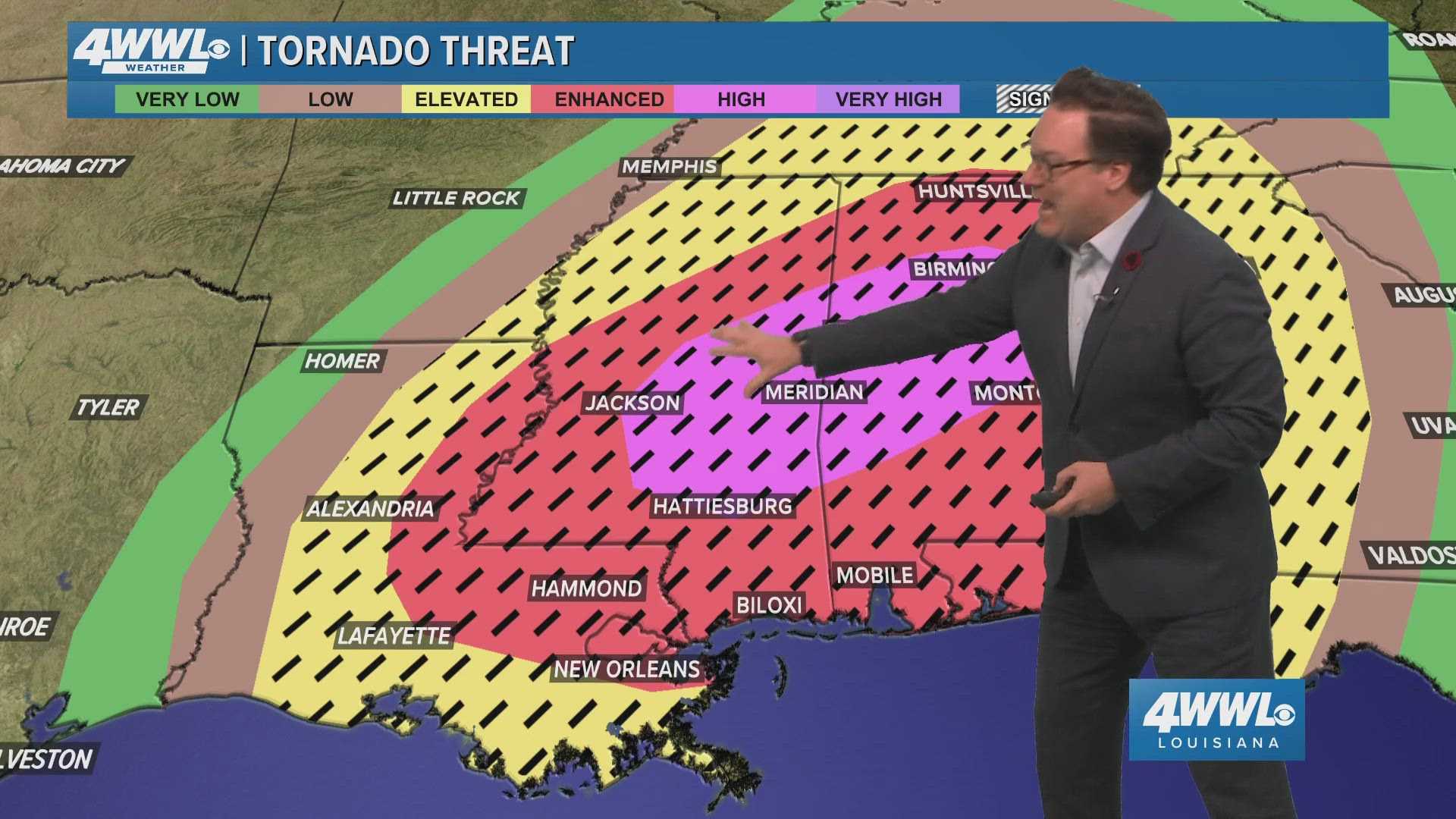
According to the National Weather Service, severe storms carrying damaging winds, large hail, and potential tornadoes are anticipated. The most serious threats, including tornadoes rated EF-2 or higher and winds exceeding 110 mph, could impact areas to the north, such as Hattiesburg and Jackson, which are currently under a level 5 risk.
The NWS emphasizes that the ingredients for severe weather are prevalent in the atmosphere, with rotation possible within thunderstorms. Early morning updates indicate a tornado watch has been issued for parts of Louisiana, with further watches likely as the storms approach.
Storm timing varies by region across southeast Louisiana. The metropolitan area of Baton Rouge is under a level 4 risk, with severe weather expected from 11 a.m. to 6 p.m. Impacts could include not only damaging winds and tornadoes but also large hail measuring one inch or larger.
The North Shore area is also classified under a level 4 risk, with severe storm activity expected between 9 a.m. and 8 p.m. River Parishes are under the same risk, with severe weather anticipated from 10 a.m. to 3 p.m. Additionally, the Bayou region and the Coast have been placed under a level 3 enhanced risk, indicating a possibility of sporadic severe storms.
“The activity ahead of the front will have every opportunity to become severe,” said a representative from the NWS. “This does not look to be a situation where storms start developing locally and then move north before becoming severe.”
Residents are advised to remain vigilant and have emergency plans in place, as forecasters warn that the conditions could lead to a historically impactful weather day for the region.
As the storm fronts approach, it is crucial for those in affected areas to monitor local news updates and weather alerts. The First Alert Weather App is recommended for tracking real-time storm developments.
After the severe weather passes, calmer conditions are expected to settle over Louisiana by Sunday, with sunny skies and temperatures forecasted in the lower 70s.