News
Severe Weather Threats Loom Over Texas and Pacific Northwest This Week
Washington, D.C. — A rare spring severe thunderstorm threat has emerged in the Pacific Northwest, while Texas braces for an unprecedented deluge that could bring up to half a year’s worth of rain this weekend.
Starting late Wednesday, a storm system originating in northern Mexico is expected to unleash heavy rainfall across South Texas, with predictions suggesting widespread rain from Wednesday night into Thursday. Rainfall rates may reach 2 to 3 inches per hour, which could lead to severe flash flooding. The Weather Prediction Center has issued warnings indicating that while the rain may provide some drought relief, it could quickly overwhelm the already dry soil.
“Unfortunately, this setup looks good enough to be a case where it’s beneficial rain initially, but then quickly overwhelms even the dry soil conditions,” the Weather Prediction Center stated.
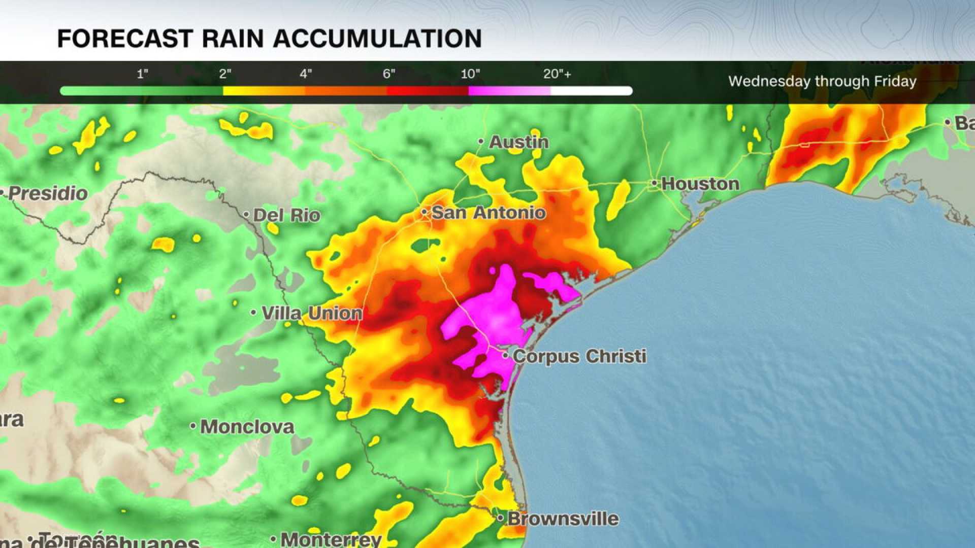
Currently, South Texas is under a level 3 of 4 flood risk, particularly in cities like Corpus Christi. The same risk level is anticipated to affect areas from Corpus Christi to just south of Houston along the Gulf coast on Thursday. Some locations may experience rainfall totals exceeding a foot, which is highly unusual outside hurricane season.
According to CNN analysis of NOAA data, Corpus Christi could see between 8 to 10 inches of rain between late Wednesday and Friday, with estimates possibly escalating to 15 inches if it remains under the heaviest rainfall. Historically, the city has never recorded 8 inches or more of rain from a storm before June.
For context, the average rainfall in Corpus Christi for March is just over 2 inches, and the city typically sees around 30 inches throughout an entire year. In the worst-case scenario, residents could witness half of the annual rainfall within a mere 72 hours.
Shifting to the Pacific Northwest, forecasters have placed parts of Washington and Oregon under a level 2 of 5 risk for severe thunderstorms Wednesday. This includes major cities like Seattle and Portland. The Storm Prediction Center indicates that severe thunderstorms will likely develop in western Oregon before moving into western Washington by the afternoon.
Residents can expect damaging wind gusts, with potential for brief tornadoes, while large hail — ranging from quarter to chicken egg sizes — poses the greatest threat. This level of severe thunderstorm risk is unprecedented for this time of year in Washington state, marking the earliest such warning on record.
Typically, severe thunderstorms are more frequent in central and southern U.S. regions during spring. However, the recent weather patterns have defied expectations, with places like Dallas experiencing large hailstorms earlier this week.


