News
Iowa Faces Potential Severe Weather as Warm Air Moves In
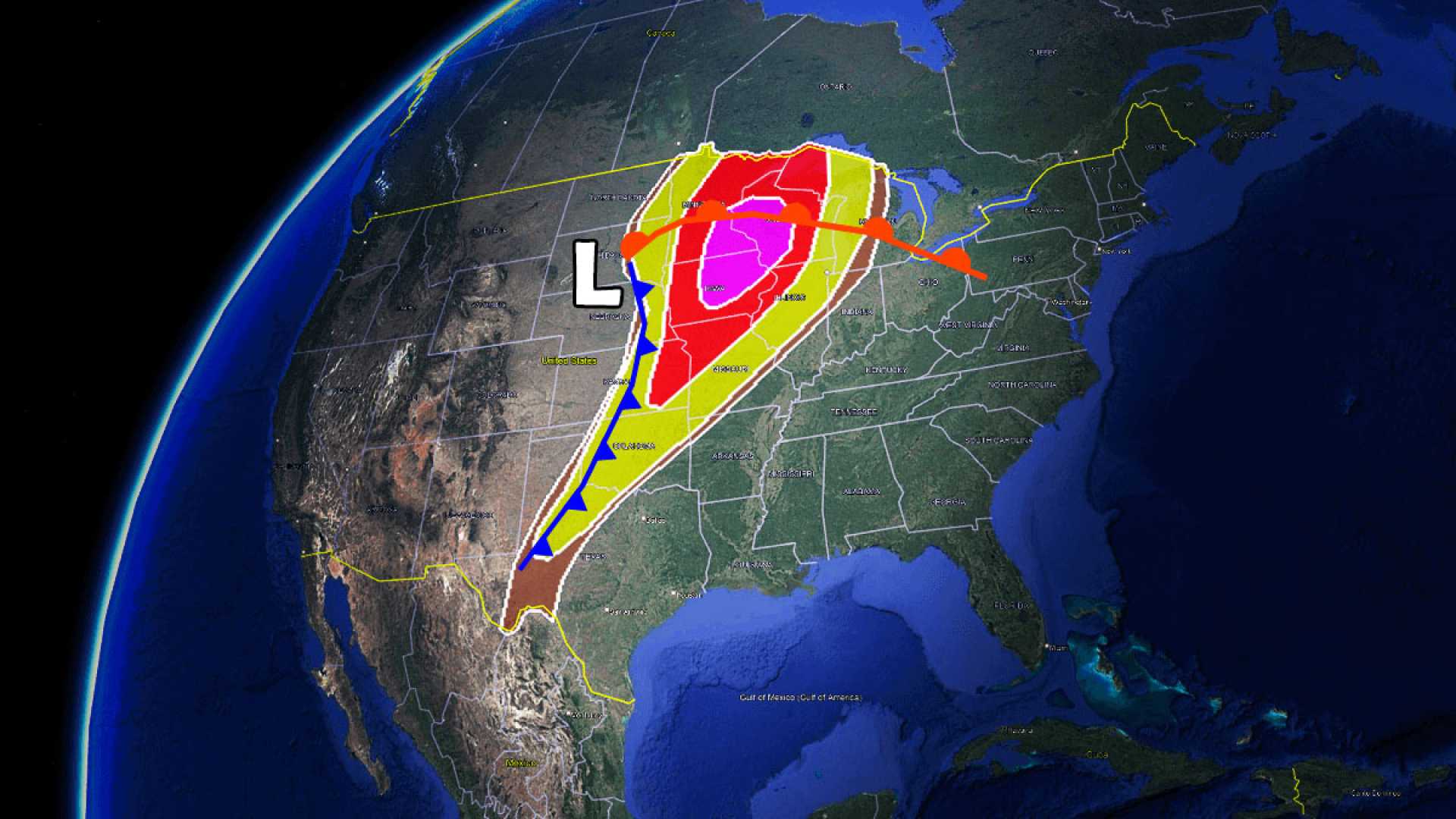
DES MOINES, Iowa — Warm and humid air is moving across Iowa today, with temperatures starting near 60 degrees and expected to reach the low 80s this afternoon. As a strong storm system approaches, the National Weather Service warns of possible severe thunderstorms throughout the day.
Gusty south winds will contribute to rising temperatures and humidity, setting the stage for scattered storms beginning in the afternoon, particularly across northern and northwest Iowa. Meteorologist Brad Edwards noted that any storm that does develop carries the potential for severe weather, including large hail, damaging winds, and even tornadoes.
The area of greatest concern is northern Iowa, which is under a level four out of five risk for severe storms. Edwards explained that storms will likely begin developing after 2 p.m., with a window extending through about 10 p.m.
“While we may not see storms everywhere, the conditions are ripe for severe activity,” said Edwards. “In particular, if storms develop in central Iowa, they could also produce severe weather, though it is uncertain how widespread that will be.”
Current forecasts predict that storms will push eastward through north-central Iowa later in the evening. Some areas may see winds gusting up to 75 mph and hail up to baseball size. However, forecasters stress that conditions are not aligned for a large outbreak of tornadoes in Iowa.
Additionally, temperatures across the region are expected to rise rapidly, reaching the high 70s by noon and peaking in the low to mid-80s later in the day. This marks the first significant warm and humid day of this spring, as dew points are expected to reach into the mid-60s.
“As the day unfolds, it’s crucial for residents to stay alert and prepared for sudden severe weather,” advised Edwards. Those in high-risk areas should keep an eye on weather alerts and be ready to take shelter if necessary.
A cold front is expected to move through tonight, bringing potential for additional storms between 8 p.m. and midnight. Though these may also be severe, the threat is anticipated to be lower than the earlier storms.
As the weather system moves out, cooler temperatures are expected Tuesday, with highs dropping into the mid-60s. Further rain chances are forecasted later in the week.


