News
NOAA Predicts Colder and Wetter Winter for Northwestern US Due to Weak La Niña

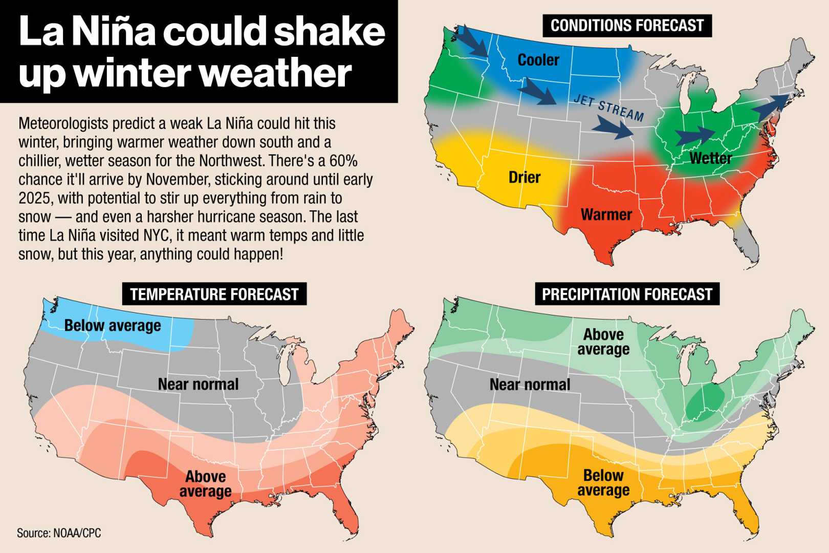
Visitors to the Paradise Lodge at Mount Rainier were greeted with a blanket of snow following one of the initial autumn snowfalls in Washington state. The National Oceanic and Atmospheric Administration (NOAA) released its winter weather outlook on Thursday, indicating a potentially chilly and wetter-than-average winter for the Northwestern United States. This pattern may extend to the Great Lakes region, which could also see increased precipitation and snow.
The NOAA’s forecast covers the period from December 1 to February 28, differing from the astronomical winter timeline, which spans from December 21, 2024, to March 20, 2025. The predictions are contingent on the development of a La Niña pattern, a natural atmospheric and oceanic circulation phenomenon that typically redirects winter storms to more northern latitudes, leaving southern states drier and warmer than usual. There is a 60% chance that La Niña will develop by late November, increasing to a 75% chance by January, according to the NOAA experts.
Jon Gottschalk of NOAA’s Climate Prediction Center noted, “Given its weak nature, we have less confidence, and some impacts might not be as widespread.” He explained during a press conference that a weak La Niña might cause changes in the jet stream position, leading to significant week-to-week weather variations.
Additionally, the escalation of global temperatures due to the climate crisis is expected to influence the winter season. As Tom Di Liberto, a NOAA climate scientist, highlighted, “Winter, for many reasons, is the fastest warming season for us.” He emphasized that long-term pattern types signal a warming trend for winter.
The anticipated pattern could exacerbate drought conditions in southern states, including Arizona, New Mexico, and Texas, which are forecasted to experience relatively warm and dry conditions. However, drought conditions are not expected to be as severe in California, though a stronger La Niña could bring above-average precipitation to the state’s northern regions.
Currently, more than a quarter of the contiguous United States landmass is experiencing at least moderate drought conditions. Brad Pugh, an operational drought lead with NOAA’s Climate Prediction Center, stated, “Winter precipitation prospects do not hint at a widespread relief from drought.”
Severe storms in the West are already beginning to deliver snowfall to mountainous areas. According to the National Weather Service, an approaching storm from the Pacific could bring as much as 40 inches of snow to higher elevations in the San Juan Mountains of Colorado.


