News
Powerful Storm Threatens Flooding and Mudslides in Southern California
LOS ANGELES, CA — A major atmospheric river storm is poised to unleash heavy rainfall across Southern California this week, with experts forecasting widespread flooding and the possibility of landslides, particularly in areas affected by recent wildfires.
According to the National Weather Service (NWS), the storm will initiate on Thursday, February 12, with predictions of 1.5 to 6 inches of rain in various regions. Meteorologist Ryan Kittell from the NWS in Oxnard advised residents to avoid travel on Thursday due to expected hazardous conditions.
“Thursday is just not a great day to be on the road,” Kittell said. “Expect slick roads and numerous traffic accidents. While some regions may experience roadway flooding, the intensity will surpass what we’ve witnessed this winter.”
Ariel Cohen, another meteorologist from the NWS, added that the heaviest rainfall is anticipated between 2 p.m. Thursday and 2 a.m. Friday. The fiercest downpours could generate debris flows, with residents in burn scar areas encouraged to evacuate when possible.
“With the high likelihood of intense rainfall rates, we could see debris flows that pick up mud, rocks, and other debris,” Cohen stated. “The risk of these flows is significantly increased in recently burned areas.”
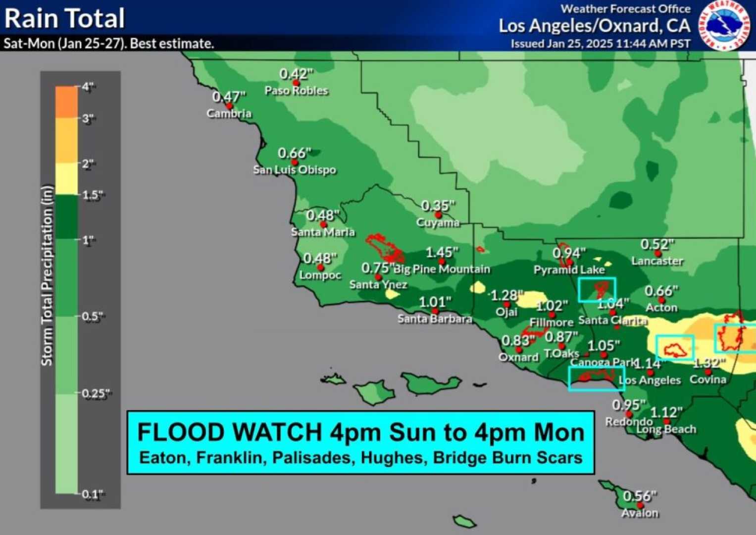
In the wake of the Palisades Fire, which devastated more than 23,000 acres in January, Los Angeles officials have implemented protective measures. Mayor Karen Bass announced that over 7,500 feet of concrete barriers and thousands of sandbags have been deployed to mitigate potential flooding and protect vulnerable communities.
“All city departments are on high alert,” Bass said during a news conference. “We are particularly concerned about safety in the Palisades area and other burn sites throughout the city.”
Forecasts predict that regions around the Palisades will receive about 3.35 inches of rain, while other affected areas could see up to 5 inches. The NWS has issued a flood watch and warnings for regions with burn scars, especially around Santa Barbara and San Luis Obispo counties, where rainfall rates could reach 1 to 2 inches per hour.
While Southern California has recently faced a drought due to insufficient storms earlier in the season, the impacts of potential mudslides and flooding this week create a new set of challenges. The NWS continues to monitor the situation, with predictions of storm activity lasting into Friday.
In response to the potential for swift water rescues, Kittell emphasized the importance of public preparedness. “Residents should stay off the roads, particularly in burn scar areas, and follow updates on the storm’s progression,” Kittell said. “If you have the option, seek safer ground.”
The storm is influenced by an atmospheric river — a phenomenon characterized by concentrated streams of moisture flowing from the Pacific Ocean that can bring substantial precipitation. This event highlights the ongoing battle against the sometimes catastrophic effects of climate-related weather patterns in California, where communities remain at risk from both drought and heavy flooding.


