News
Severe Storms Expected Across Central and Eastern U.S. This Weekend
ST. LOUIS, Mo. — A powerful low-pressure system is forecast to wreak havoc across the Midwest, South, and East this weekend with threats of tornadoes, damaging winds, large hail, and flash flooding. The severe weather outbreak is expected to begin as early as Friday and continue through Sunday, affecting millions.
According to the National Oceanic and Atmospheric Administration’s (NOAA) Storm Prediction Center, areas most at risk include parts of the Mississippi Valley and the lower Ohio and Tennessee valleys. Cities like St. Louis, Memphis, Tennessee, and Jackson, Mississippi, are among those under serious threat as the storm system progresses eastward.
Forecasts indicate that severe thunderstorms may first occur on Friday afternoon, with the risk lingering into the overnight hours. “It’s crucial for residents to have a safety plan in place and multiple ways to receive weather alerts,” said meteorologist Jane Doe from the National Weather Service. “This system could produce significant severe weather conditions.”
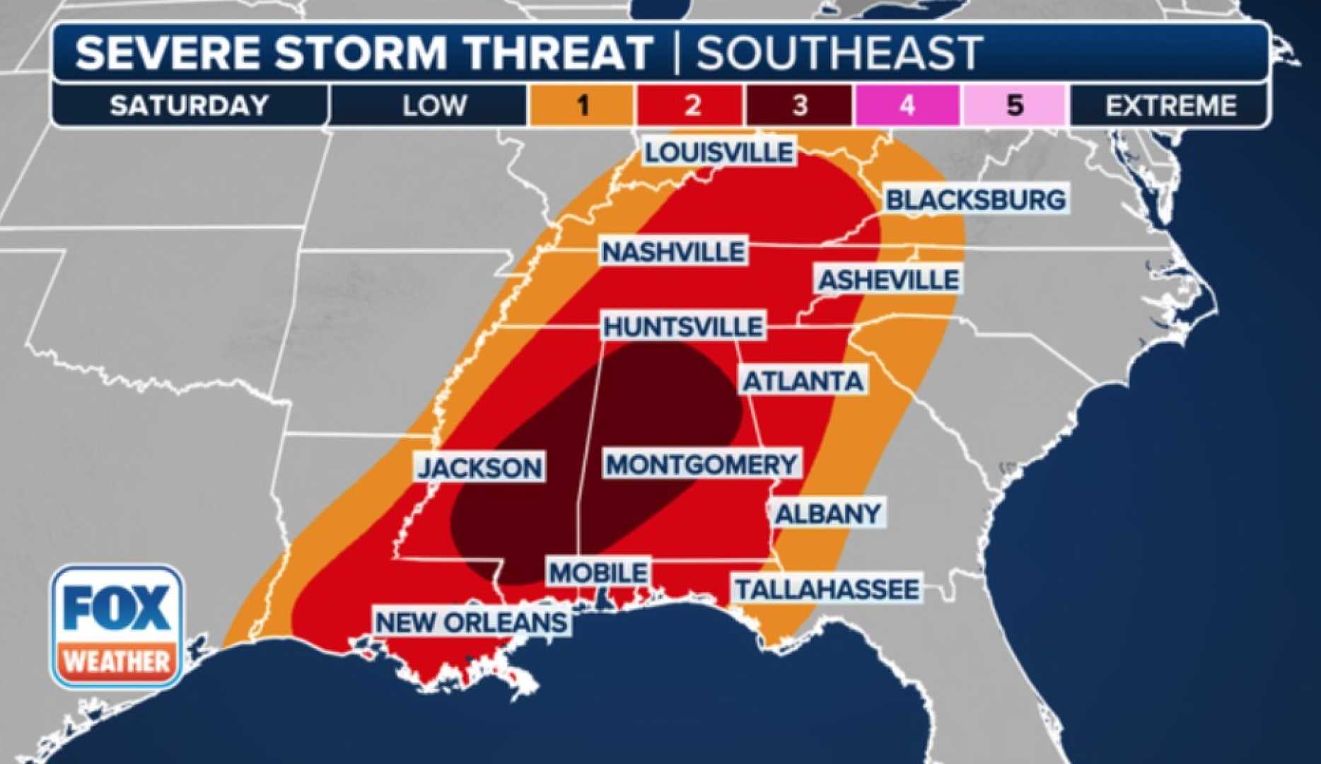
The Deep South—specifically Alabama, Georgia, Louisiana, Mississippi, Tennessee, and parts of the western Florida Panhandle—faces the highest risk of severe storms. Forecasters have flagged cities like Atlanta, Birmingham, and New Orleans as particularly vulnerable.
The potential for tornadoes, some possibly rated EF2 or stronger, exists throughout this outbreak. In addition to tornadoes, damaging wind gusts and large hail are also significant concerns, particularly from the afternoon through the evening, as atmospheric instability increases.
Current charts suggest thunderstorms will extend into the mid-Atlantic states as the weekend progresses. Locations like Charleston, South Carolina, and Washington, D.C., may also experience lingering storms, potentially leading to localized flash flooding and strong winds.
The forecast models indicate that conditions are ripe for rapid development of severe thunderstorms across various regions. Meteorologists express caution and emphasize that these patterns can create supercell thunderstorms capable of producing destructive winds, heavy rain, and tornadoes.
As of now, more than 8.5 million people in the central U.S., including parts of Mississippi and southern Illinois, are under a level 3 out of 5 risk of severe weather on Saturday. This hazardous scenario encompasses major cities such as Montgomery, Alabama, and Jackson, Mississippi.
The severity of the weather is expected to taper somewhat on Sunday, although damaging wind threats will persist. The Storm Prediction Center has indicated that over 41 million people along the East Coast, including major urban areas from Florida to Washington, D.C., may still face severe weather risks.
“While the threats may shift in nature from day to day, it’s critical to remain vigilant,” added Doe. With ongoing uncertainties in storm coverage, the focus remains on the impact these storms could have as they make their way across the country.


