News
Severe Storms Expected From Plains to Midwest This Week
SEATTLE, WA — A new wave of severe storms is anticipated to hit the central and southern United States from late Tuesday into the weekend. The forecast indicates a significant tornado threat along with destructive straight-line winds and damaging hail.
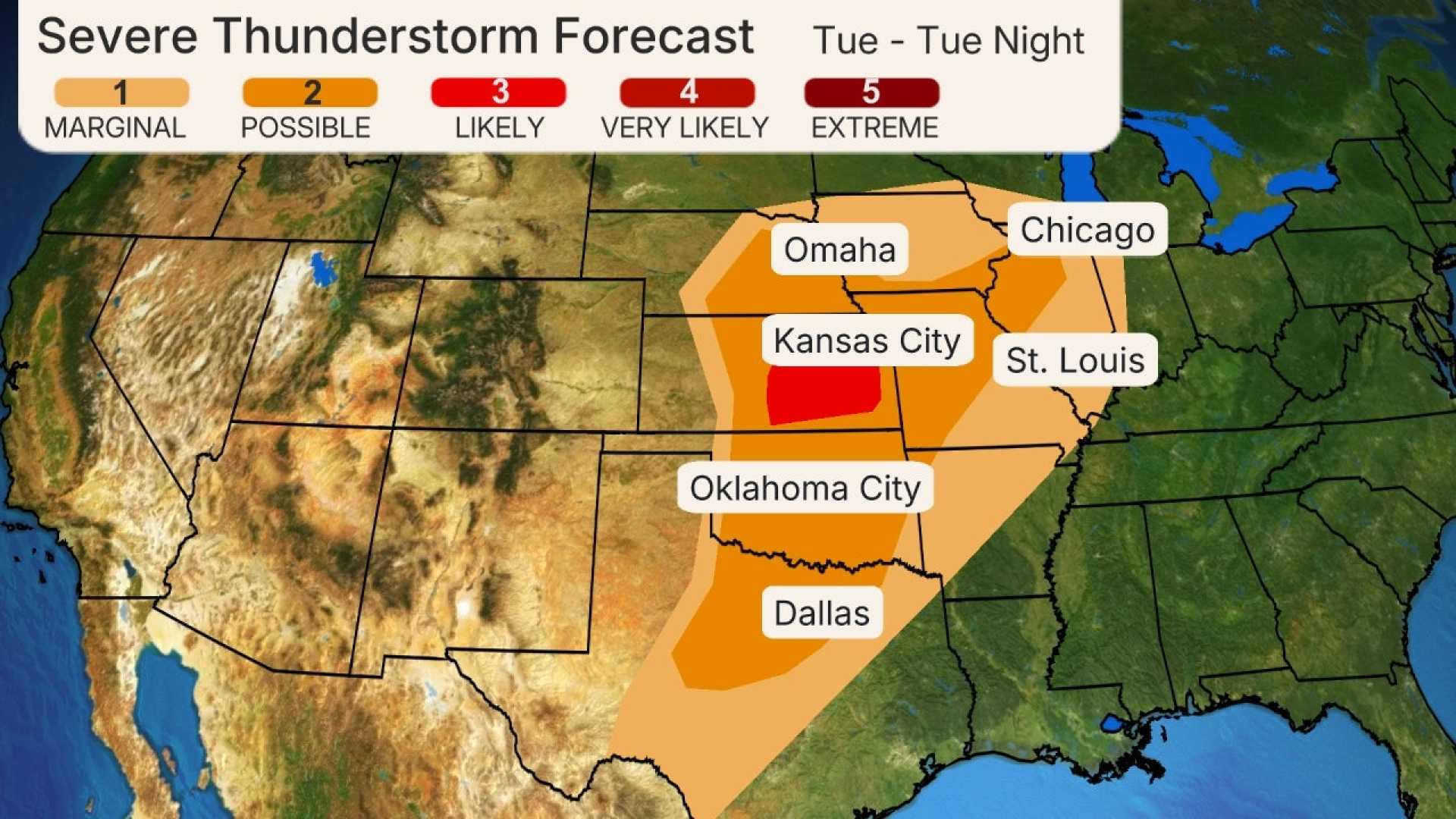
As early as Tuesday evening, severe storms could develop from northern Texas extending through Oklahoma, Kansas, eastern Nebraska, Iowa, Missouri, and northwest Illinois. Cities such as Dallas-Fort Worth and Oklahoma City may experience intense weather conditions.
Large hail and strong winds are expected as storms intensify across these regions, especially in eastern Kansas where strong tornadoes may emerge. Additionally, the formation of supercell thunderstorms in parts of Oklahoma and north Texas could result in large hail and wind gusts, with a few tornadoes possible.
As the system moves eastward on Wednesday, the area of severe weather will expand from the Great Lakes to northeast Texas, impacting the Ohio, Mississippi, and Tennessee valleys. Cities including Chicago, Indianapolis, and Little Rock are prime areas for severe weather, as indicated by the Storm Prediction Center.
“One or more clusters of strong to severe storms will be ongoing into Wednesday morning,” a spokesperson from the National Weather Service said. “These storms are expected to intensify throughout the day, leading to potentially hazardous conditions.”
The afternoon and evening will bring an additional wave of severe storms stretching from the mid-Mississippi Valley to the ArkLaTex. Antecedent conditions increase the likelihood of intense tornadoes, along with large hail and damaging winds overnight across the Tennessee and Ohio valleys.
A cold front will stagnate during the latter part of the week, contributing to a multi-day flood risk. Rainfall totals in parts of northeast Texas, the Mississippi and Ohio valleys are predicted to reach double digits, with some areas seeing up to 15 inches.
Residents in flood-prone zones are advised to monitor National Weather Service updates regarding flood watches and warnings. Safety precautions include avoiding flooded roads, as only one foot of water can float most vehicles.
“People should stay alert and prepared in case of evacuation orders,” a meteorologist stated. “Knowing where to find higher ground is critical.”
With over 100 million people at risk of severe weather, the NOAA emphasizes vigilance. Several areas, including Indianapolis and St. Louis, fall under an “enhanced risk” category, indicating the possibility of widespread severe storms capable of producing hail of two inches in diameter and wind gusts exceeding 58 mph.
Residents are cautioned to understand the difference between weather watches and warnings. Watches indicate that conditions are right for severe weather while warnings suggest imminent threats. Preparedness is crucial during severe weather events.
Weather patterns contributing to these storms include a strong low-pressure system in the region, coupled with warm, moist air moving in from the Gulf of Mexico. This situation enhances the potential for severe thunderstorms, with damaging winds, large hail, and tornadoes on the horizon.
The Storm Prediction Center employs a five-tier risk category to illustrate the severity of weather events. “There’s a prime risk for damaging winds and tornadoes,” expressed an NWS official, “and we encourage everyone to take these warnings seriously.”


