News
Severe Storms and Tornadoes Expected This Weekend in Tri-State Area
EVANSVILLE, Ind. (WFIE) – The Tri-State region is preparing for a series of severe storms, including damaging winds, strong tornadoes and large hail, beginning late Friday night and continuing into early Saturday. The National Weather Service has issued a high-risk warning for the area, predicting conditions for potentially life-threatening weather.
The storm system is expected to reach the Tri-State between midnight and 3 a.m., with a second round forecast for Saturday afternoon and evening. Areas particularly susceptible to flash flooding include southern Indiana and western Kentucky, where repeated storms may lead to localized flooding. By late Saturday night, all severe weather is anticipated to move out of the Tri-State.
As temperatures soar to near-record highs of 82 degrees on both Friday and Saturday, the region will experience gusty winds with speeds reaching 40-50 mph. Following the storms, temperatures will drop into the lower 50s, with partly sunny conditions expected on Sunday. A further temperature rise is anticipated early next week, with highs returning to the 70s.
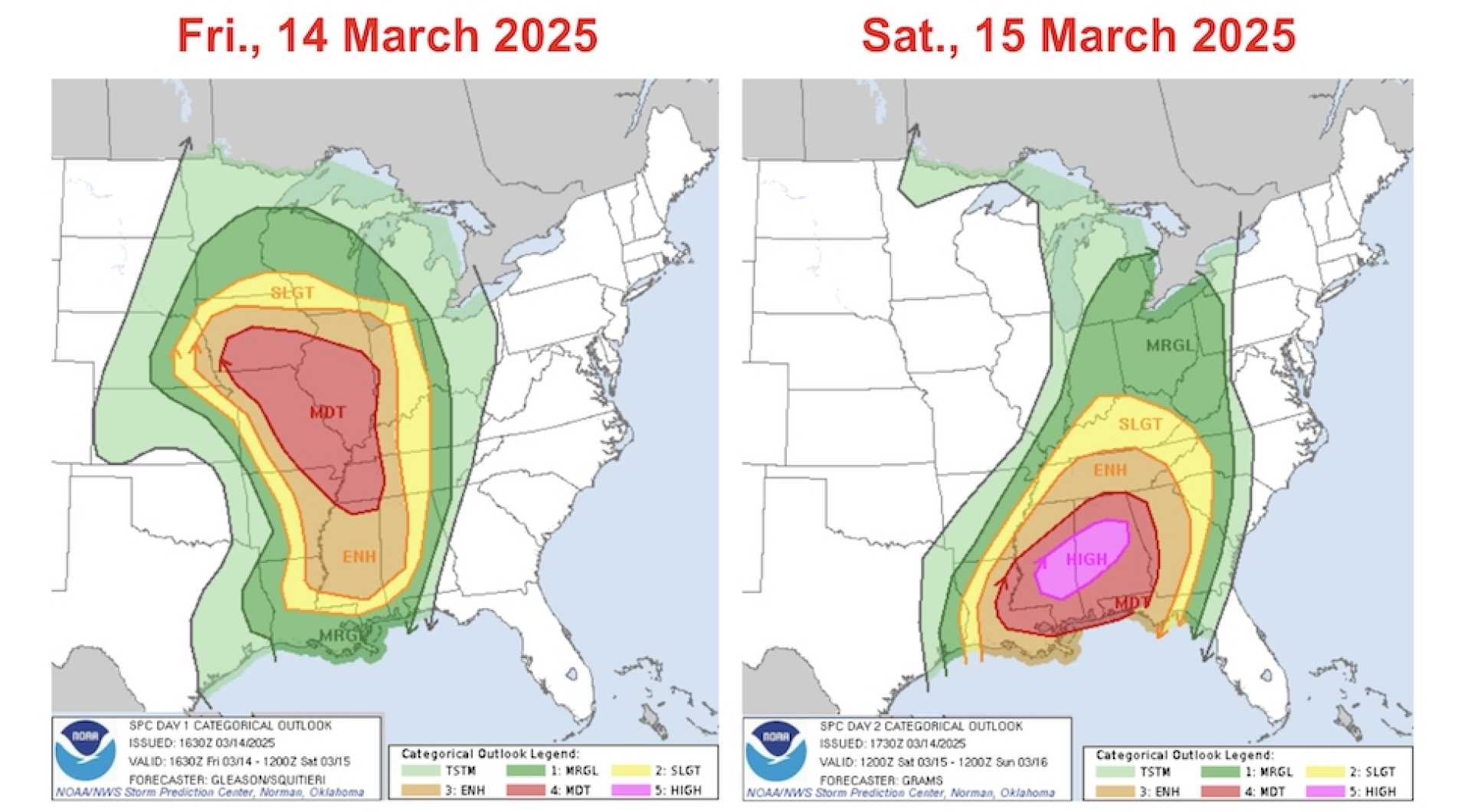
The upcoming weekend’s severe weather will not be limited to the Tri-State area. NOAA‘s Storm Prediction Center has issued a level 4 out of 5 risk for severe weather on Friday, escalating to a level 5 risk last seen only once or twice a year. This denotes a high likelihood of supercell thunderstorms capable of large, damaging tornadoes and widespread winds.
Bill Bunting, operations branch chief for NOAA, highlighted the seriousness of the situation: “This storm has it all. The moisture is plentiful, and all of these ingredients—wind shear, moisture, and lift—will combine to produce a highly explosive and potentially deadly storm.”
The severe weather outbreak has already begun, with sightings of numerous tornadoes across the Midwest, including around St. Louis. Heavy storms are expected to cover a broad area from the Great Lakes to the Gulf Coast, with the peak of the severe weather migrating eastward throughout the weekend.
Significant tornadoes and widespread damaging winds are possible in states such as Alabama, Mississippi, Tennessee and the Florida Panhandle. Cities like Birmingham and Jackson are under a level 5 risk, indicating heightened danger.
“Residents in these areas should remain in storm shelters when the storms arrive, particularly from mid-afternoon into the evening,” warned forecasters, stressing the need for preparedness.
As the storm moves east, a cold front may generate additional severe weather from the Southeast into the Mid-Atlantic, affecting states like South Carolina, North Carolina and Virginia. Intense thunderstorms, localized flash flooding, and potentially damaging winds will remain concerns through early next week.
Emergency management officials are urging individuals to remain vigilant and monitor local weather updates. As severe thunderstorms sweep through the area, residents are advised to avoid unnecessary travel and remain indoors during peak storm activity.


