News
Severe Thunderstorms Expected to Strike Central Ohio This Weekend
COLUMBUS, Ohio — Central Ohio is bracing for severe thunderstorms this Saturday, as the National Weather Service (NWS) has issued a weather advisory due to the threat of strong storms. The advisory will remain in effect through Saturday until 8 p.m.
Two distinct rounds of storms are anticipated to impact the region. The first wave, characterized by scattered showers, is expected to roll through Saturday morning, primarily bringing moderate rainfall with some potential for gusty conditions. While most of these showers will remain non-severe, forecasters caution that there may be isolated strong wind gusts.
According to the NWS, the bulk of severe weather associated with this first round will predominantly affect areas to the west in Indiana, particularly late Friday into early Saturday.
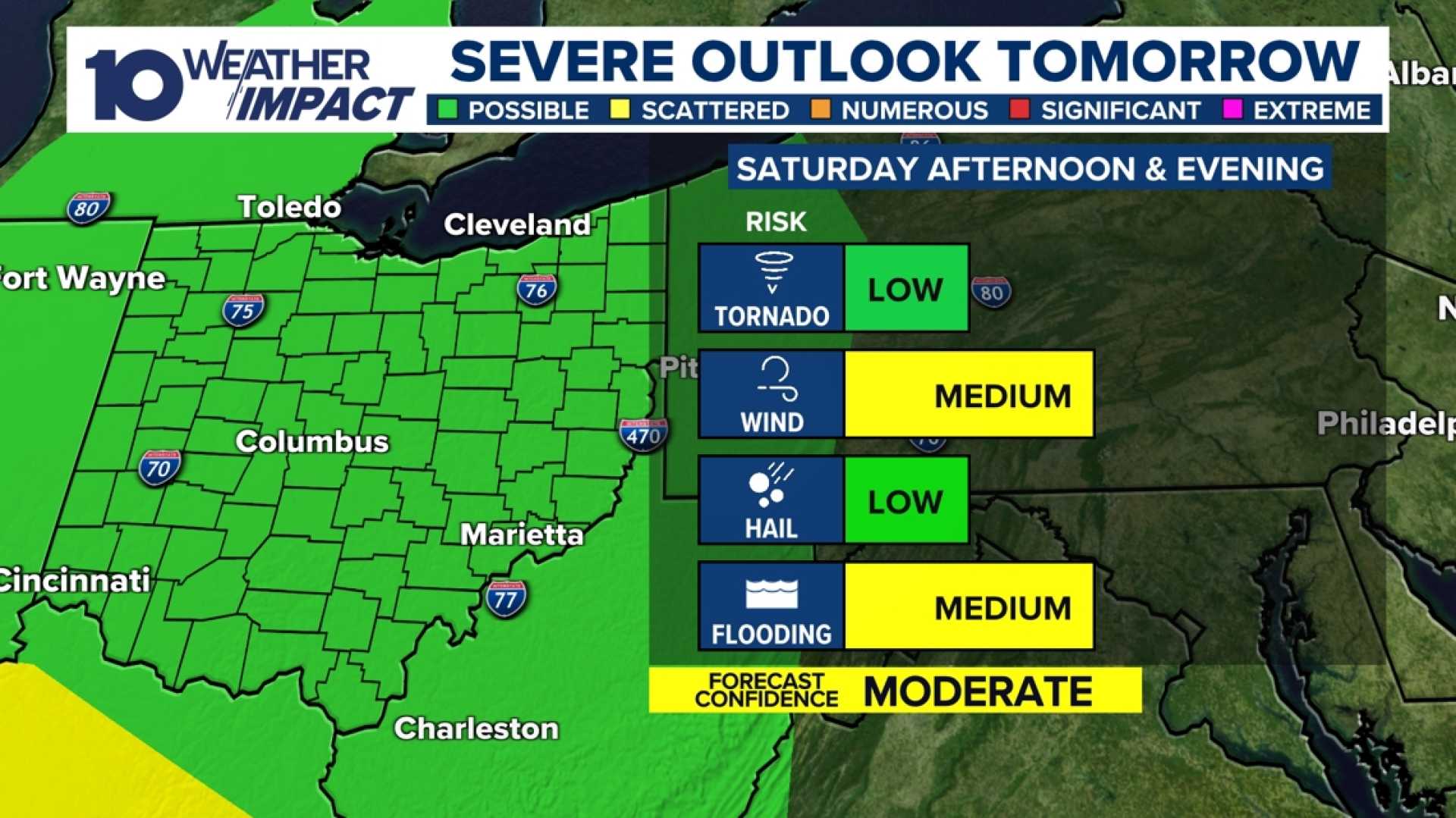
The second, more intense batch of showers and storms will arrive Saturday afternoon and last into the early hours of Sunday. Meteorologists predict that these storms will likely be stronger, driven mainly by wind but also carrying the potential for hail and even tornadoes, with activity expected to taper off after 10 p.m.
Michael Behrens, a meteorologist with the NWS, warned, “The biggest concern during this weekend’s storms will be the heavy rainfall, which may lead to localized flooding. Our models indicate we could see between 1 to 2 inches of rain, with some areas exceeding 2 inches.”
This storm system is prompting a level 1 out of 4 risk for flooding across most of Central Ohio, especially in the southwestern regions surrounding Columbus. Flooding risks will persist following the storms, with periods of heavy rain expected to continue into Sunday.
In conjunction with the storms, wind gusts could reach up to and exceed 40 mph on Saturday, which poses additional risks for tree damage and power outages. ”Gusty winds will blow around unsecured objects and could lead to broken tree limbs,” the NWS cautioned.
As temperatures are set to soar into the 70s on Saturday, a significant drop is expected by Sunday. Forecasters predict highs in the 60s on Sunday, continuing to decline into the 50s by Monday.
Residents are urged to stay weather-aware throughout the weekend and to take precautions against the severe weather. With potential for flooding and severe storms, individuals should monitor the latest weather updates.
The 10 Weather Impact Team will provide ongoing coverage of the situation, with additional updates expected as new information becomes available.


