News
Severe Thunderstorms Threaten Upper Midwest With Tornadoes and Hail
MINNEAPOLIS, Minnesota – Millions of residents in the Upper Midwest are bracing for severe thunderstorms that could spawn tornadoes and large hail this Monday afternoon into evening. This weather system is part of a broader pattern of extreme weather expected across the country this week.
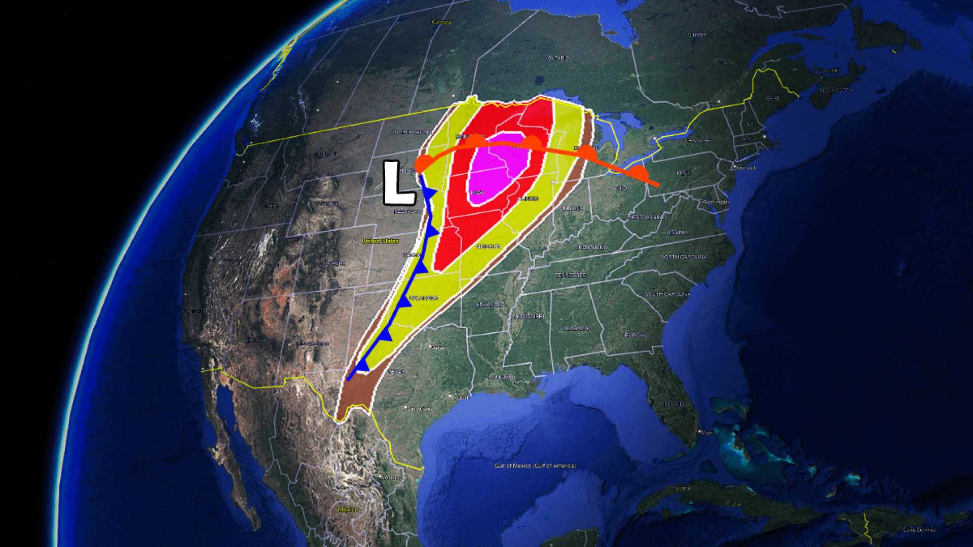
The severe weather started to develop early Monday, with initial thunderstorms forming in Minnesota, Iowa, and Wisconsin. The Storm Prediction Center reported a risk assessment of level 4-out-of-5 for severe weather in these areas, putting approximately 35 million people at risk from Texas to northern Minnesota.
By early afternoon, reports of damaging storms began to surface, including golf-ball-sized hail falling in southwestern Minnesota. The National Weather Service emphasized that late afternoon and evening hours will be particularly dangerous, indicating a peak threat for tornado formation.
Over five million people in eight central U.S. states are under tornado watches, which include major cities like Minneapolis, Des Moines, and Oklahoma City. Multiple tornado watches have been issued for states such as Minnesota, Iowa, and Oklahoma, with specific warnings about potential hail larger than baseballs and wind gusts exceeding 75 mph.
As the storms advance, additional waves of thunderstorms may develop, each potentially bringing significant threats. The National Weather Service noted that the current atmospheric conditions are conducive to creating severe weather, with a high chance of intense storms for the rest of the day.
Reports from around the region include a tornado observed near Kenyon, Minnesota, which caused structural damage to a farm. Other damage reports include blown roofs in Minnesota and Kansas, as hail and high winds wreak havoc across the area.
Looking ahead, severe thunderstorm threats are forecasted to continue into Tuesday, with an extension covering over 1,800 miles from Texas to Vermont. Areas including Ohio, Pennsylvania, and New York are also expected to witness severe weather activity on Tuesday afternoon.
As conditions evolve, a significant flood threat accompanies the storms, particularly in Texas and Oklahoma, where heavy rainfall has already saturated the ground. Flash flood watches are in place for multiple areas, warning of potentially life-threatening flooding conditions.
The severe weather pattern threatens to persist for several days, with meteorologists continually monitoring the developing storms. This event reflects an ongoing trend observed in the U.S., where numerous tornado events have occurred consecutively over the past weeks.


