News
Severe Weather Alert: Hurricane-Force Winds, Tornadoes Expected This Weekend
ST. LOUIS, Mo. — Over 100 million residents across the central and eastern United States are on alert for a severe weather outbreak anticipated to begin Friday, March 14, 2025. Meteorologists from FOX Weather are warning that this dangerous system could unleash thunderstorms with hurricane-force wind gusts and strong tornadoes.
The FOX Forecast Center indicates that the severe weather is likely to commence Friday afternoon and may persist into the overnight hours as a powerful storm system intensifies over the central U.S. Forecasters caution that all severe weather hazards, including destructive wind gusts and tornadoes, are possible throughout the event.
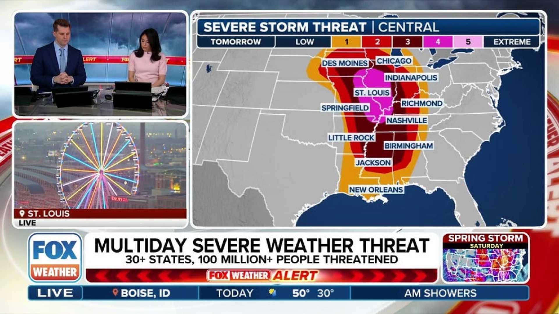
The greatest tornado risk stretches more than 750 miles, from Mississippi to sections of the Midwest, and encompasses an overall threat spanning over 1,000 miles. The FOX Forecast Center expects significant storm activity to develop in northern Missouri and Iowa before moving eastward into the Mississippi Valley.
Initial moisture from the Gulf of Mexico is deemed limited, but it is projected to rise northward into the Mississippi Valley, potentially affecting areas as far north as Iowa and parts of southwestern and northern Illinois.
Nearly 70 million individuals are at risk on Friday; however, more than 6.5 million residents in specific regions of Missouri, Iowa, Illinois, Indiana, and Arkansas are under a level 4 out of 5 risk category as determined by the Storm Prediction Center (SPC). Major cities in the highest threat zone include St. Louis, Mo., and Peoria, Ill.
On Saturday, March 15, the storm system is expected to continue its eastward movement, putting tens of millions from the Gulf Coast to the southern Great Lakes at risk for severe thunderstorms. The SPC has expressed uncertainty about how conditions will destabilize further north, but expectations are high for a corridor of rich Gulf moisture to develop from central and southern Mississippi into northern Alabama.
This setup is likely to create favorable conditions for severe weather preceding the advancing storm system. With atmospheric instability, the forecast suggests a fast-moving squall line capable of generating hail, damaging winds, and tornadoes, compounded by the potential for heavy rainfall.
Currently, over 6.5 million people in Louisiana and Alabama are at a level 4 out of 5 risk for severe weather. Cities like Baton Rouge, La., and Mobile, Ala., are highlighted in this elevated threat zone.
As the weekend progresses into Sunday, an emerging concern arises for millions along the East Coast, particularly within the heavily trafficked Interstate 95 corridor, from Washington, D.C., to Boston. Although the severe threat on Sunday has a wider geographic spread, forecasters note that the potential for hail and tornadoes diminishes, leaving primarily a risk of damaging winds.
The SPC has classified over 45 million people, from northern Florida to the Mid-Atlantic, at a level 2 out of 5 risk for severe weather on Sunday. This includes metropolitan areas such as Jacksonville, Fla., Charleston, S.C., Richmond, Va., and Baltimore, Md.


