News
Severe Weather Alerts Issued as Tornado Watch Looms Over Alabama
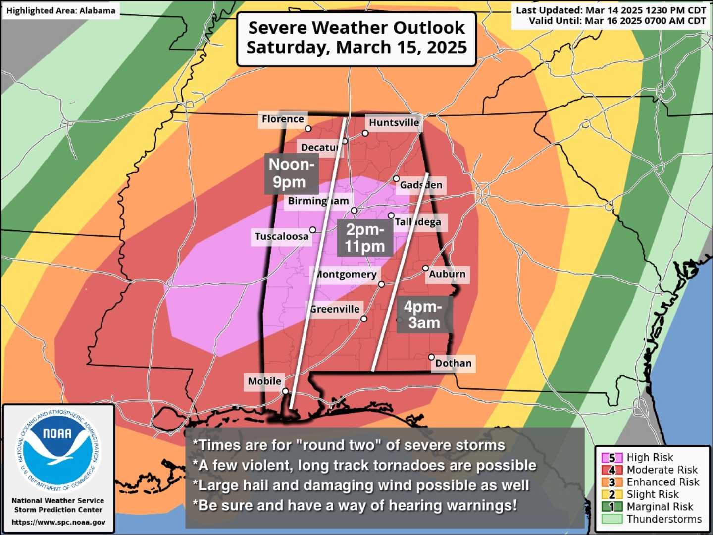
BIRMINGHAM, Ala. — The National Weather Service issued a tornado watch for over a dozen Alabama counties on Saturday, March 15, 2025, amid expectations of severe storms including tornadoes, damaging winds, and large hail. The watch is in effect until 8 p.m. and encompasses counties including Jefferson, Tuscaloosa, and Shelby.
This alert follows a significant weather forecast predicting dangerous conditions, with the service labeling this as a “particularly dangerous situation.” Meteorologists expect strong tornadoes to develop alongside severe thunderstorms this afternoon and into the evening, with tornado activity beginning to intensify in the state.
According to the Storm Prediction Center, several tornadoes, some possibly long-tracked and intense, are anticipated. “A high risk of tornadoes has been noted, potentially producing significant weather impacts across the region,” said Chief Meteorologist Jason Simpson on WVTM 13. “Residents in mobile homes or less fortified structures should seek shelter immediately.”
The severe weather is expected to escalate throughout the day, with the first storm activities initiating around 11 a.m. and lasting well into the night, with hazardous conditions persisting through at least 1 a.m. Sunday.
As a precaution, residents are urged to have multiple methods in place for receiving weather alerts and to develop safety plans ahead of time. The National Weather Service advises that anyone in vulnerable areas should evacuate to designated storm shelters if possible.
“Conditions are favorable for the development of significant tornadoes this afternoon due to a strong jet stream and an advancing low-pressure system,” said a spokesperson from the NWS. Forecast models suggest that this pattern could lead to multiple severe weather outbreaks with excessive rainfall, potentially leading to flooding in some regions.
Winston, Marion, Walker, Blount, Cullman, and Etowah counties face a moderate risk for flooding, with isolated areas predicted to receive over two to three inches of rain. The NWS reminds residents, “Turn around, don’t drown,” emphasizing the dangers associated with driving through floodwaters.
Forecasters anticipate that while significant rainfall and strong winds will accompany these storms, maintaining alertness and following safety guidelines could save lives. “The effects of this storm system could be felt well beyond Alabama, impacting states all the way to Georgia and the Florida Panhandle,” added the NWS.


