News
Severe Weather Threats Loom Over Eastern Iowa and Evansville Region
CEDAR RAPIDS, Iowa (KCRG) – Eastern Iowa is preparing for a day of severe weather as conditions deteriorate throughout the region. A Wind Advisory is currently in effect, predicting wind gusts up to 50 mph from mid-afternoon through early evening. Alongside these strong winds, warm temperatures have prompted the National Weather Service to issue a Red Flag Warning due to heightened wildfire risks.
Residents are strongly urged to take precautions as the risk of wildfires significantly increases. At the same time, a Severe Thunderstorm Watch affects parts of the TV9 viewing area. Today’s temperatures are forecasted to near record highs, contributing to the unusual weather pattern observed.
A line of severe thunderstorms is expected to move rapidly through the area, tracking from southwest to northeast late this afternoon and particularly this evening. The primary threats associated with these storms include damaging winds exceeding 80 mph, which could result in extensive damage to structures and trees. Tornadoes and isolated large hail are also possible, raising concerns about the severity of the impending weather event.
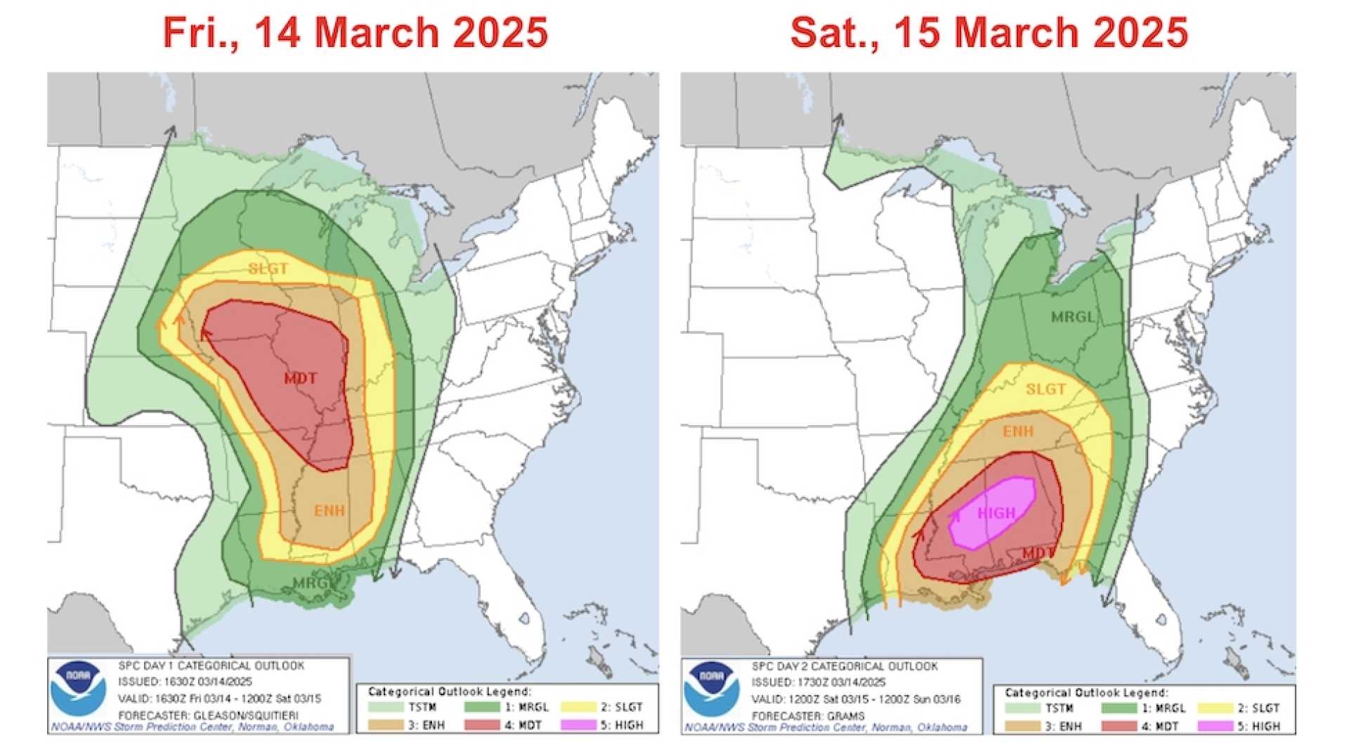
The Storm Prediction Center has designated Eastern Iowa under Enhanced to Moderate Risk statuses, indicating a higher likelihood of severe weather. Following the thunderstorms, strong winds are anticipated to persist into late tonight and Saturday, maintaining blustery conditions across the area.
The following day will bring cooler temperatures, starkly contrasting today’s warmth. However, forecasts predict a rebound in temperatures for Monday and Tuesday ahead of a midweek system that could introduce further weather changes.
This weather event marks the first significant risk for severe storms this season. It is crucial for residents to review safety measures should a warning be issued. Because storms will move swiftly, the time to react could be shorter than usual. If a storm approaches your area, seek shelter indoors immediately.
If a warning is issued, retreat to the lowest floor of your home, away from windows. In the case of a tornado warning, try to place as many walls as possible between yourself and the outside—an interior closet or bathroom is ideal. A basement provides the best shelter. Protect your head and neck with pillows or blankets, or even a bike helmet if available.
Those in mobile homes should leave for sturdier structures as soon as possible. If caught outdoors without immediate access to a shelter, lying flat in a ditch and covering your head and neck is recommended. Residents should avoid seeking shelter under overpasses or bridges.
Having multiple ways to receive warnings is essential. A NOAA Weather Radio can be a valuable tool and should be prepared in advance to ensure readiness to receive alerts before bed. Regular updates will also be available on KCRG.com and KCRG-TV9 as conditions warrant.
Meanwhile, in Evansville, Indiana, the National Weather Service has voiced concern regarding the potential for severe thunderstorms later tonight. Forecasters indicate that the most likely window for severe weather is from 11 p.m. Friday to 5 a.m. Saturday, with the chance of a second round of severe weather on Saturday afternoon.
The primary threats include widespread damaging winds and tornadoes, along with significant severe weather possibilities classified as winds of 70-75 mph—equating to hurricane-force winds—and tornadoes rated EF2 or higher on the Fujita scale. Models predict a broken line of severe thunderstorms developing over central Missouri Friday afternoon, moving east into the Tri-State area.
Wind shear ahead of the storms is expected to contribute to their severity, with south winds of 35-50 mph preceding the storm line. After a brief lull, additional severe storms with heavy rainfall may arrive Saturday afternoon over Western Kentucky and Southwestern Indiana.
The Storm Prediction Center has classified much of Southern Illinois and parts of far Western Kentucky as a ‘moderate risk’ area for severe thunderstorms while the Evansville area remains at an ‘enhanced risk’ level, one tier below moderate risk.
Rainfall estimates indicate that Evansville could see between 1.5 and 2 inches through Sunday, with some regions in Western Kentucky possibly experiencing up to three inches of rain on Saturday afternoon. Historically, the last moderate risk day was recognized as a highly impactful event that resulted in tornadoes near Mortons Gap, Kentucky, and Fort Branch, Indiana.


