News
Winter Storm Warnings Issued for Southern New Jersey Ahead of Major Snow Event
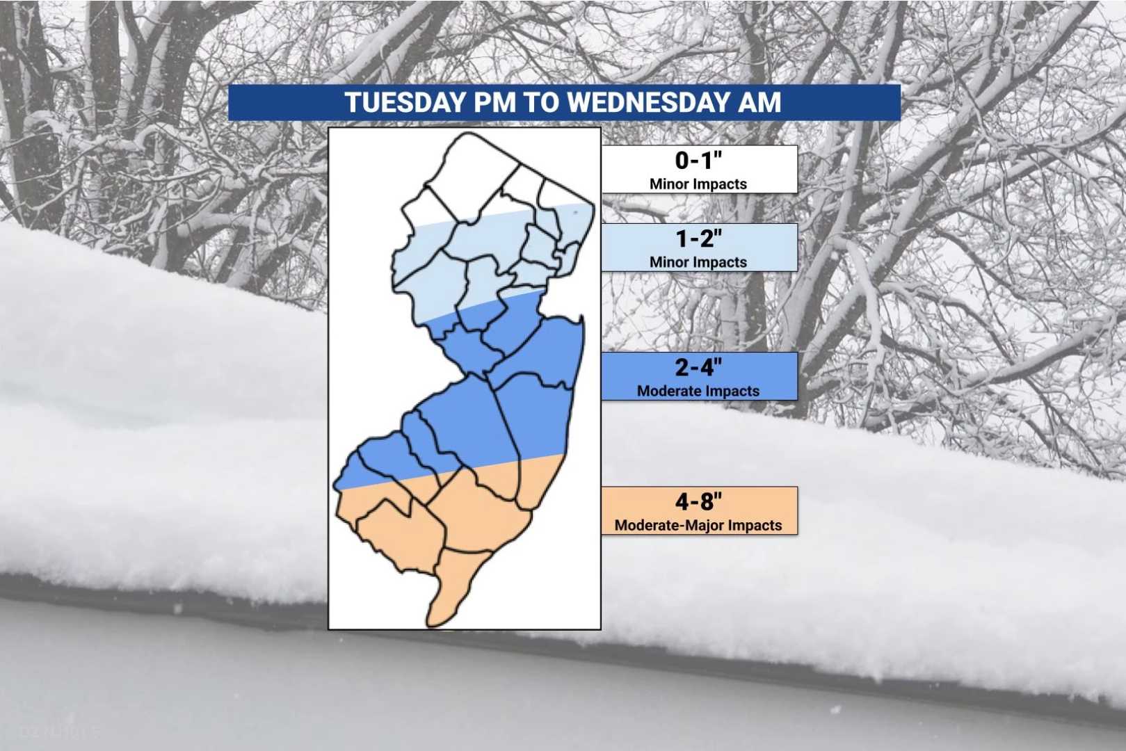
ATLANTIC CITY, N.J. — Southern New Jersey is bracing for severe winter weather as forecasters predict significant snowfall beginning Tuesday afternoon. Winter storm warnings have been issued for Atlantic, Cape May, and Cumberland counties, with the potential for up to six inches of snow by Wednesday morning.
The warnings will be in effect from late Tuesday afternoon through early Wednesday morning, as a powerful storm system approaches the region. The National Weather Service expects the most significant accumulation in South Jersey, while other counties, including Burlington, Camden, Gloucester, Mercer, Monmouth, Ocean, and Salem, are under winter weather advisories.
“Snowfall rates could exceed one inch per hour in southern New Jersey,” stated a meteorologist from the National Weather Service. “Widespread accumulating snowfall is likely and could impact both the Tuesday evening and Wednesday morning commutes.”
The storm system is just one of three forecasted to affect the region within the next week, following a series of wintry conditions that have previously affected the Garden State. The second system will arrive Wednesday morning, likely delivering more snow and sleet before transitioning to rain by Thursday afternoon.
Forecasts indicate that the Wednesday-Thursday storm may bring 1 to 2 inches of snow in southern counties and up to 3 inches in the northern areas. “As future storms develop, we will continue to monitor the situation and adjust our forecasts accordingly,” the meteorologist noted.
Drivers are advised to exercise caution, as road conditions are anticipated to deteriorate rapidly. Snowfall from the initial storm is projected to taper off by late Tuesday evening or early Wednesday morning. Meteorologists also caution that the next storm moving in later this week could bring a wintry mix, contributing to ongoing hazardous conditions.
Atlantic, Burlington, Camden, Cape May, Cumberland, Gloucester, Ocean, and Salem counties remain under close watch, as total snow accumulations could reach localized totals near eight inches. “A series of low-pressure systems will pass south of the area, bringing several waves of snow between Tuesday and Wednesday,” explained the National Weather Service report.
For now, residents are encouraged to prepare for potentially delayed travel and check local forecasts frequently as conditions evolve. In the meantime, drivers will face slippery road conditions across the region as snow begins to accumulate.


