News
Winter Storms Sweep Across U.S., Affecting 80 Million with Severe Weather
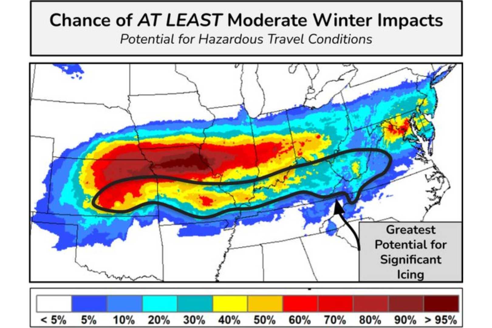
ST. LOUIS – A series of winter storms is currently impacting more than 80 million people across the United States, stretching from the Midwest to the East Coast. The National Weather Service has warned of heavy snow, ice, and potentially severe weather as two distinct systems move through the country this week.
The first storm brought heavy snow and ice to the Ohio Valley and is expected to continue affecting the Mid-Atlantic region through Wednesday. In a morning advisory, the service noted, “Significant ice is forecast for the Central Appalachians.” Meanwhile, a second winter storm is moving quickly from the Mississippi Valley into the Central Plains, potentially bringing hazardous conditions.
CBS News meteorologist Nikki Nolan stated, “The storm will produce heavy snow from northeast Kentucky into West Virginia, extending through the I-95 corridor from Richmond to Philadelphia.” Accumulations could reach between 4 to 8 inches, with localized snowfall rates hitting 1 inch per hour. Residents in the storm’s path are warned of possible isolated power outages and treacherous travel conditions, particularly during the Tuesday evening rush hour.
In contrast, the southern edge of the storm is forecasted to unleash heavy rain which may lead to flash flooding, particularly in the Lower Mississippi and Tennessee Valleys. The intersecting weather systems have resulted in various warnings being issued, with extreme cold advisories in the Northern Rockies, Great Lakes, and Central Plains where temperatures could plummet 25 to 35 degrees below average.
Areas in Chicago and Hastings, Nebraska, are preparing for significant snow accumulation while parts of Virginia and West Virginia brace for up to half an inch of ice. Forecasters expect that additional winter weather may blanket further regions with more than 10 inches of snow this week.
The FOX Forecast Center is tracking the unfolding storm, which has already begun to cover central Plains and mid-Valley areas with snow on Tuesday. This storm represents the most severe winter weather that regions like Springfield, Missouri, have seen in years, potentially causing the snowiest day in over a decade.
The latest forecasts do indicate a substantial risk for icy conditions in places like Kansas City and Kentucky, with heavy snow and strong winds leading to reduced visibility and hazardous travel. Snow will continue moving eastward, aiming toward the Tennessee River Valley and beyond.
Winter Weather Watches and Warnings are in effect from central and eastern North Carolina to western Virginia, with forecasters predicting 5 to 10 inches of snow accumulation. The convergence of conditions is likely to result in challenging travel situations on Wednesday afternoon, particularly along major highways.
Meanwhile, flooding risks have also been forecasted across southern states, with particular concern for areas extending from Texas to Georgia due to heavy rainfall from the storms.
This gives a critical overview of what residents and travelers can expect as the winter weather system progresses eastward over the next few days, with implications for both snow and ice accumulation across a wide swath of the United States.


