News
Wintry Mix Expected as Piedmont Triad Faces Weather Alerts
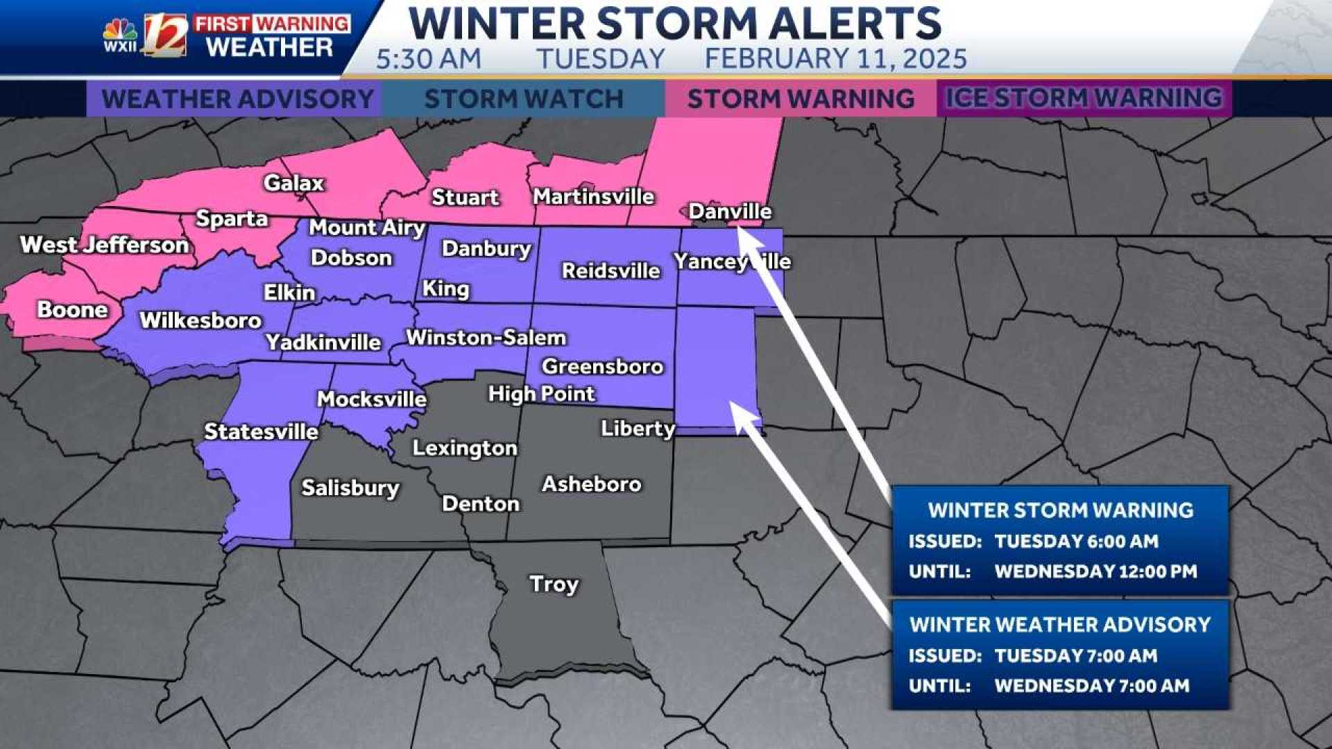
WINSTON-SALEM, N.C. — An impending winter weather system is poised to affect the Piedmont Triad and mountainous regions of North Carolina on Tuesday morning, bringing snow, sleet, and freezing rain north of Interstate 85.
The National Weather Service has issued Winter Weather Advisories and Storm Warnings for multiple counties, predicting a notable wintry mix from around 4 a.m. until noon, transitioning to rain by the afternoon. Slick travel conditions are expected during the early morning hours.
The forecast model suggests that areas north and west of the Triad may experience accumulations of snow and ice, with ice totals of up to half an inch in some mountainous regions. A tenth of an inch of ice accumulation is also possible across northern counties of the Piedmont.
“Travelers should be cautious, especially in the early morning hours,” said a representative from the local weather team. “We advise residents to prepare for potentially hazardous conditions, especially on bridges and elevated roads.”
The timing indicates that icy conditions could start developing before sunrise, with heavier precipitation expected to follow as temperatures gradually rise throughout the day. Areas south of I-85 are forecasted to see mainly cold rain, with little to no icing.
In terms of precipitation amounts, forecasters are estimating that much of the Triad could see between 1 to 2 inches of rain by Wednesday night, with flooding possible in the mountains where totals could reach 3 to 4 inches.
As for Wednesday morning, meteorologists are continuing to track the likelihood of freezing rain, particularly near the Virginia border. While daytime temperatures are expected to rise above freezing, the potential exists for lingering icy spots in the early hours.
The upcoming weather pattern will be accompanied by significantly colder temperatures, with highs only reaching the low 30s on the worst-affected days. The forecast will remain dynamic, with updates provided as storm conditions develop.
“We have been relatively dry in recent weeks, so this moisture is beneficial but we must also be vigilant for localized flooding as the rain accumulates,” the weather team emphasized. “Stay tuned for continued updates and alerts throughout the week.”
Residents are encouraged to download the WXII 12 News mobile app for real-time weather alerts, and check local news sources for ongoing weather coverage and updates on road conditions.


