News
Severe Weather Threat Looms Over Central and Eastern U.S. This Weekend
JACKSON, Miss. (AP) — A severe weather system is expected to affect a large portion of the United States starting Tuesday, March 11, bringing damaging storms, hail, and the possibility of tornadoes across many states. Meteorologists are warning that millions could be impacted as the storm system moves eastward from the Rockies into the southern Plains.
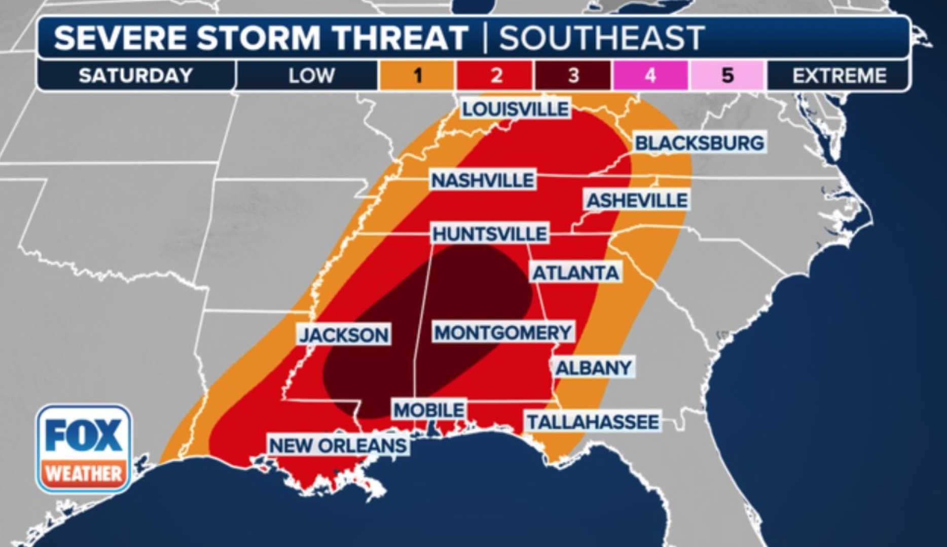
The FOX Forecast Center predicts a significant increase in severe weather risk beginning Wednesday across the Ark-La-Tex region, where damaging winds and tornadoes could occur. NOAA’s Storm Prediction Center (SPC) describes a particularly dangerous weather pattern developing Friday and Saturday that could extend from the Central Plains to the Gulf Coast.
“Severe storms with a risk of tornadoes, damaging winds, and hail are expected from the Ark-La-Tex to the lower Mississippi Valley this weekend,” the SPC stated. The threat is anticipated to shift east on Saturday, affecting areas including Mississippi and Alabama.
The approaching system will rapidly intensify, raising concerns about blizzard conditions in northern regions, particularly the Dakotas. These areas are under high alert for significant snowfall and power outages as a result of the severe weather.
“The weather will begin on Tuesday as an innocuous front, but it could transform dramatically as it approaches the Mississippi River by midday,” said Britta Merwin, a FOX Weather meteorologist. The storm is expected to bring widespread damaging winds with gusts upwards of 60 mph, along with a substantial risk for flash flooding.
Central and eastern U.S. residents are also cautioned about the potential for a severe wildfire threat due to dry conditions paired with gusty winds from the system.
In a notable incident on Monday morning, severe weather claimed two homes in Central Florida as a tornado struck while FOX 35 Orlando was broadcasting live. FOX 35 Meteorologist Brooks Garner urged viewers to seek shelter as the tornado touched down, though fortunately, there were no reported fatalities or serious injuries.
Additionally, as the system moves through, a separate cold front is expected to bring transitional weather into next week, with near-average temperatures returning by Monday. Observers noted that highs could hover in the lower 70s on Tuesday, providing one last warm day before another cooler trend sets in.
As this severe weather system unfolds, residents are urged to remain vigilant, stay informed via local news outlets, and have a plan in place to protect themselves and their property.


