News
Flash Flood Warning Hits St. Louis Region Amid Heavy Rain
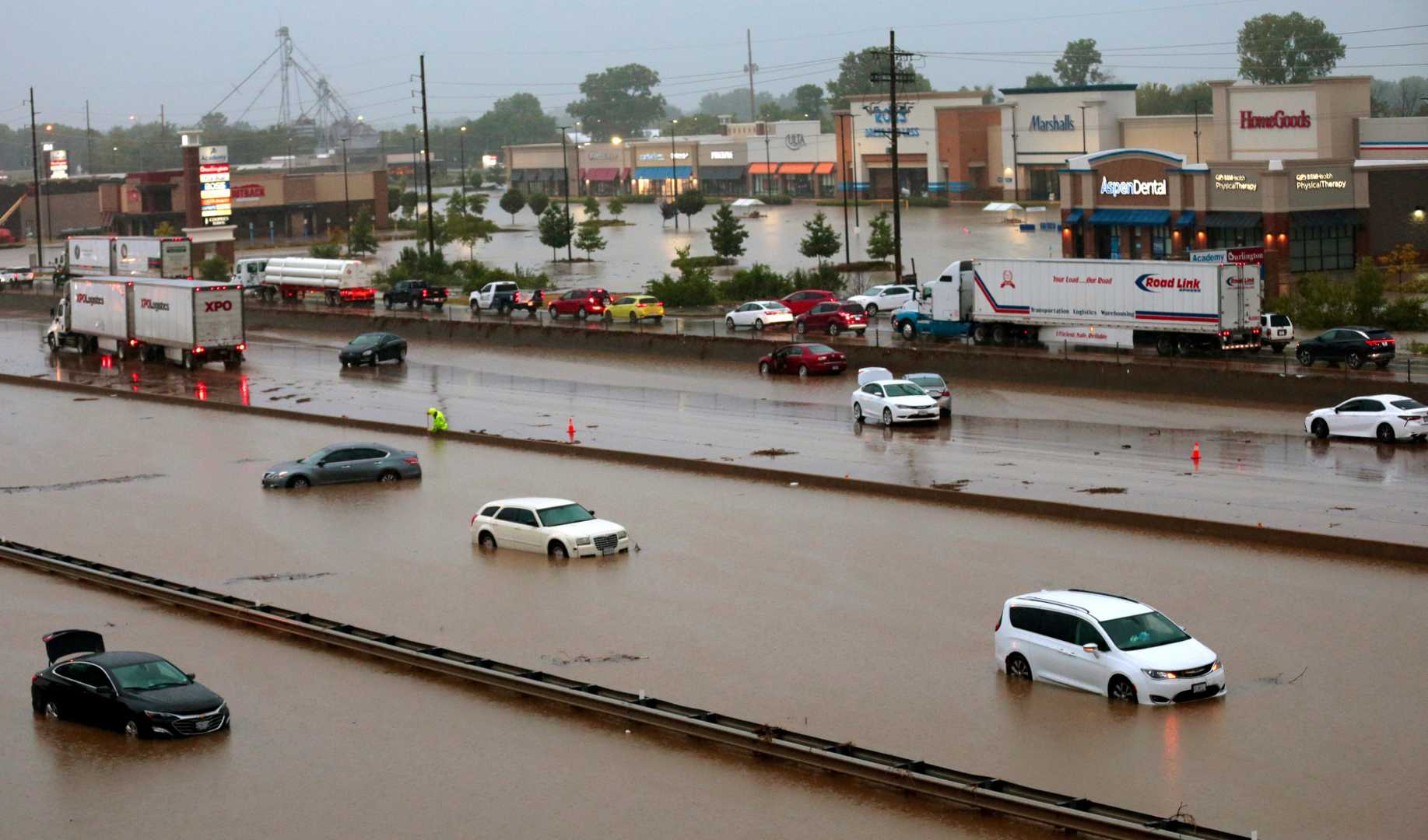
ST. LOUIS — The St. Louis area was placed under a flash flood warning Tuesday afternoon due to heavy rainfall totaling 2 to 3 inches in a short time. The National Weather Service (NWS) issued the warning for several counties in Missouri and Illinois, including St. Louis, St. Charles, St. Clair, and Madison.
Shortly before 4 p.m., the St. Louis Metropolitan Police Department announced that Interstate 70 eastbound was closed at Bircher and Salisbury because of flooding. Numerous roads throughout the city turned into temporary ponds, with the intersection at Chouteau Avenue and South Tucker Boulevard reporting a stranded vehicle in deep water.
The heavy rain also impacted interstates 44, 55, and 64, leading to further travel disruptions. The St. Louis Fire Department warned residents against driving through standing water, emphasizing that even a small amount of water can pose significant dangers. Just six inches of water can stall a car, while a foot can sweep it away.
The NWS confirmed the slow-moving storm system was responsible for the flooding, remaining stationary over certain neighborhoods for hours. As a result, rainfall totals quickly reached levels that drainage systems could not handle, turning local streets into impassable waterways.
Emergency management officials urged residents to stay away from flooded areas, highlighting the deceptive nature of such conditions. They noted that even shallow-looking floodwaters could quickly become dangerous and lead to life-threatening situations.
The flooding extended beyond St. Louis, impacting Jefferson and Franklin counties as well, and officials warned that the threat might spread into south-central Illinois later in the day. Commuters across the region experienced major travel disruptions, particularly on lesser-known routes.
Local emergency services monitored conditions and assisted stranded motorists, as unpredictable flash flooding made it difficult for drivers to anticipate road danger. Conditions could change rapidly, with passable roads becoming hazardous within hours.
Although rain was expected to diminish by evening, the NWS warned that scattered showers could persist into Saturday morning, and similar flooding could develop in areas to the east as the storm system moved across the Midwest.
As residents begin to clean up in areas where water levels receded, the situation serves as a reminder about the urgent need to stay informed during severe weather events. Emergency management officials reiterated important flood safety principles to help keep residents safe.


