News
Severe Thunderstorms Expected in Nashville and Kentucky Friday Evening
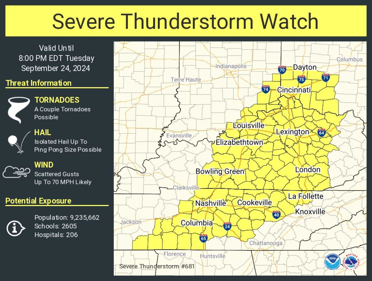
NASHVILLE, Tenn. (WSMV) – A First Alert Weather Day is in effect for Friday afternoon and evening due to the possibility of strong to severe thunderstorms across the Midstate.
The severe weather threat has been rated at a 2 out of 5 on the scale, with the main dangers being damaging wind gusts and heavy rainfall. The strongest storms are expected between 3 p.m. and 10 p.m. today, but additional showers may continue overnight into Saturday morning.
In addition to high winds, some storms could produce hail as small as peas to dimes, and an isolated tornado cannot be ruled out. Weather forecasts indicate uncertainty regarding the strength of storms that may develop overnight.
BOWLING GREEN, Ky. (WBKO) – As for today’s weather in Bowling Green, skies will start clear but could feature patchy fog tonight. Warm temperatures in the upper 80s and lower 90s are expected, with scattered showers and thunderstorms developing later.
The risk for severe storms remains, with potential for strong winds and heavy rainfall. A slight chance of isolated hail and tornadoes persists, particularly in the evening hours. While the tornado risk will diminish overnight, persistent rain could lead to localized flooding.
The rest of the weekend is predicted to bring cooler and drier weather, with temperatures in the 70s and 50s for overnight lows.
LOUISVILLE, Ky. — According to WHAS, a cold front will move across Kentucky and southern Indiana on Friday, bringing the possibility of strong storms. A warm front is also expected to raise humidity and temperatures today, leading to clearer skies during the morning.
This weather pattern may create optimal conditions for thunderstorms this evening, especially south and east of the Louisville Metro. Residents are advised to stay alert, particularly those attending high school and college football games.
As the storms move through, high winds, heavy rain, and hail are potential threats. While the severe storm threat may decrease overnight, rain is expected to continue through early Saturday, making way for clearer, cooler weather.


