News
Winter Storm Chan to Impact Midwest and Northeast This Week
CHICAGO, Illinois — A new winter storm, named Winter Storm Chan by The Weather Channel, is set to bring additional snow to the Midwest after Winter Storm Bellamy previously impacted holiday travel. The storm will then move toward the East, forecasted to deliver a wintry mix of snow and ice on Tuesday and Tuesday night.
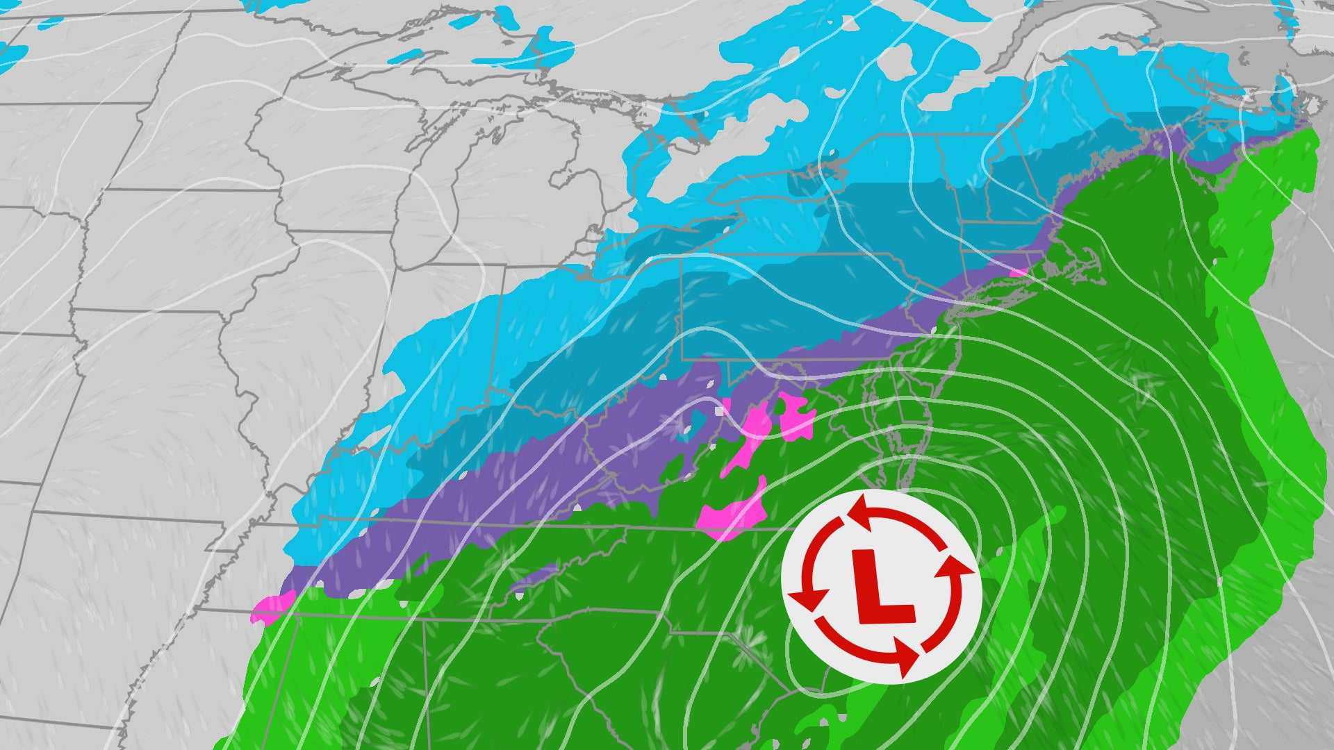
According to radar reports, light snow is currently falling in parts of the Plains, with some areas in Oklahoma and Arkansas experiencing light sleet or freezing rain. Oklahoma City reported icy overpasses and bridges on Monday morning, prompting warnings for drivers due to snowy road conditions.
The National Weather Service has issued winter weather advisories across the Plains, Midwest, Appalachians, and parts of the Northeast. These advisories indicate that lighter wintry precipitation may lead to slippery travel. Winter storm watches are also in effect for parts of the Northeast, including northeast Pennsylvania to Maine, indicating that heavier snowfall is expected in those areas.
While the Midwest is anticipated to receive light to moderate snow amounts Monday, ranging from 1 to 3 inches, the Northeast could see more significant snow accumulation. Areas just north of New York City into New England may receive 6 inches or more on Tuesday, with localized amounts potentially reaching up to a foot in parts of Massachusetts and southern Maine.
This storm system may complicate travel on Tuesday and Tuesday night, especially in areas where snow-covered roads are expected to persist into Wednesday morning. Strong wind gusts are probable along coastal eastern New England late Tuesday into Wednesday as the storm approaches Atlantic Canada.
Despite the rough weather, temperatures will not rise above freezing for the entire week, ensuring that any snow will stick around. The upper-level pattern will contribute to cold and unsettled weather across the Midwest and Great Lakes regions.
While snow is expected, areas of sleet and freezing rain will also occur, particularly from North Carolina to West Virginia early Tuesday. The southern Appalachians could see ice accumulation that may affect road conditions and lead to power outages in some regions.
Major cities such as Boston, New York City, Philadelphia, and Washington, D.C. have already experienced their first flakes of the season, though none have reported measurable snowfall yet. Rain is predicted to be the dominant precipitation type in D.C., Philadelphia, and New York City, although some wet snowflakes may fall at the beginning or end of the precipitation.
Boston has the highest chance of measurable snow, with wet snow expected to begin late Tuesday night, according to Tiffany Savona, a meteorologist for weather.com. Savona’s expertise in forecasting spans over 15 years.


