News
Tropical Storm Humberto Forms, Imelda May Follow This Weekend
Winston-Salem, N.C. — Tropical Storm Humberto has formed in the Central Atlantic, and another storm, likely named Imelda, could develop soon. Humberto is currently about 550 miles northeast of the Leeward Islands and is moving west-northwest with sustained winds of 40 mph.
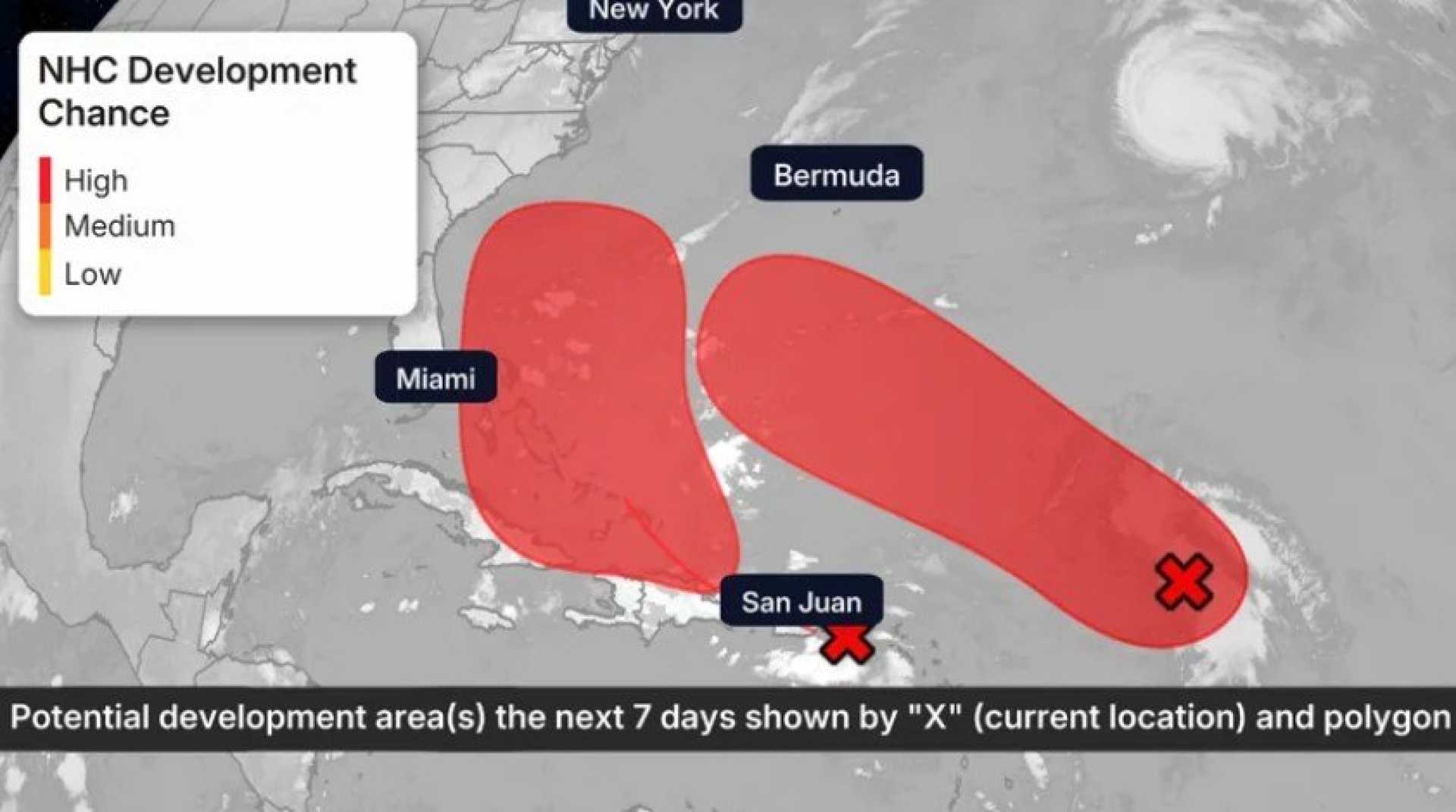
While Humberto is expected to steer clear of the mainland United States, forecasters are keeping a close eye on Invest 94L, located several hundred miles east of the Leeward Islands. This system may strengthen into a hurricane by early next week and could pose a threat to the Bahamas, Bermuda, and possibly parts of the Southeast U.S.
The National Hurricane Center (NHC) is monitoring the situation closely. Recon missions by Hurricane Hunter aircraft are scheduled to assess the system’s environment and movement. Current models suggest Invest 94L might develop into a tropical storm by this weekend, just as it approaches the Bahamas.
“Invest 94L has an 80% chance of development as it brings heavy rains and potential flooding to Puerto Rico and the Virgin Islands this week,” said an NHC spokesperson. “As it moves westward toward the Bahamas, there is a possibility of it gaining strength.”
Invest 93L, another tropical wave located east of the Lesser Antilles, is also being monitored and has a 90% chance of development. Depending on which system intensifies faster, it could be named Humberto or Imelda. This system could impact Bermuda or North Carolina based on its projected path.
Forecasters emphasize the need for coastal residents in the Southeastern U.S., especially from Florida to North Carolina, to remain vigilant and monitor the storms’ progress. Models indicate that interactions between these two systems could complicate their predicted paths, an effect meteorologists refer to as the Fujiwhara effect.
Historically, late September to October witnesses increased storm activity in the Atlantic, and these developments come as the 2025 Atlantic hurricane season continues. With warm ocean waters acting as fuel for tropical systems, the potential for storms remains high.
As of now, the NHC is urging all residents in the Bahamas, the U.S. East Coast, and Bermuda to stay updated on forecasts and prepare for possible impacts, which may include strong winds, heavy rains, and coastal flooding.


