News
Hurricane Erin Causes Rip Currents and Coastal Flooding on East Coast
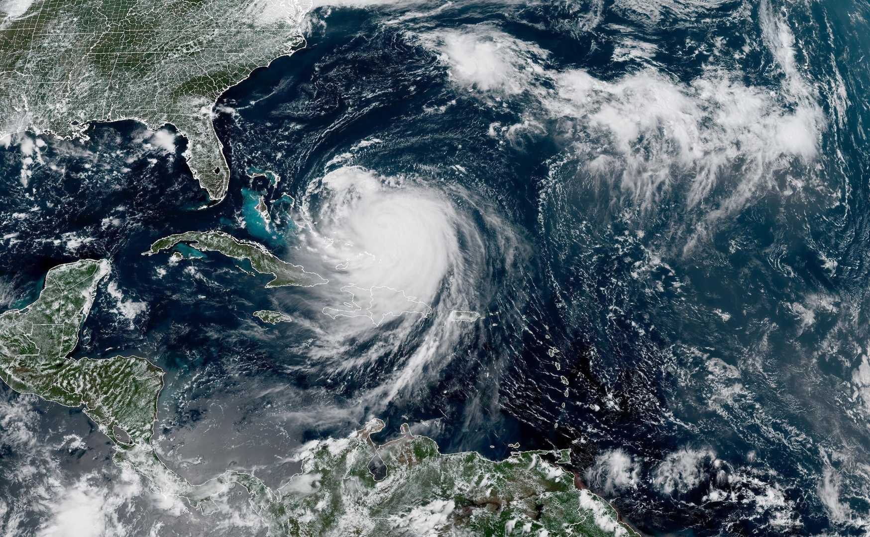
NEW BERN, North Carolina — Hurricane Erin is unleashing life-threatening rip currents and hazardous surf along much of the U.S. East Coast. The storm is expected to bring destructive waves and storm surge to North Carolina’s Outer Banks in the coming days.
As a high-end Category 2 hurricane with sustained winds nearing Category 3 status, Erin is not anticipated to make landfall. However, it will affect many coastal areas as it tracks northward, almost parallel to the coastline. Bermuda is also expected to experience dangerous conditions as the storm approaches.
The impact of Erin is already evident along the North Carolina coastline. Officials reported about 90 rip current rescues on Monday alone, with over 75 rescues taking place in New Hanover County. Wrightsville Beach has issued a no-swim advisory that will be effective through Friday.
A tropical storm watch is in effect from the middle of the North Carolina coast north to Duck, which includes the Pamlico Sound area. This watch indicates that tropical storm-force winds, ranging from 39 to 73 mph, are possible within 48 hours.
Dare and Hyde counties, which encompass most of the Outer Banks, have already declared local states of emergency and initiated mandatory evacuations for Hatteras and Ocracoke Islands. North Carolina’s Highway 12, a critical route connecting the Outer Banks, may become inaccessible for several days due to expected coastal flooding.
Further south, tropical storm warnings remain active for the Turks and Caicos Islands and the southeastern Bahamas, while a watch is in place for the central Bahamas. Erin’s outer bands have already impacted these regions, resulting in flooding, power outages, and airport closures.
The hurricane intensified rapidly to a Category 5 over the weekend, making it one of the fastest storm strength increases on record in the Atlantic. Despite fluctuations in its strength, Erin remains a substantial threat.
Over the following days, Erin’s winds are expected to push up to 4 feet of storm surge onto the Outer Banks, leading to significant coastal flooding. The National Weather Service has raised concerns about extensive beach erosion, with waves of 20 feet or more anticipated.
The threats include potential collapse of protective sand dunes and extreme flooding inland. Cape Hatteras National Seashore officials reported that some Outer Banks homes remain vulnerable, highlighting at least two houses in Rodanthe that may be at risk of falling into the ocean.
Adding to the risk, the tides around the Outer Banks will be at their highest levels of the month midweek, which could exacerbate flooding issues. The storm’s extensive winds, which currently extend over 200 miles from its center, are expected to increase further, affecting a broad area.
As hurricane season enters its busiest period, the National Hurricane Center is also monitoring other areas for potential tropical development in the Atlantic. The first area has a moderate chance of evolving into a tropical depression this week, while another area near Cabo Verde islands has a lower chance of development.
Forecasters are monitoring these systems closely as they can still impact regions within the Caribbean and southeastern U.S.


