News
Hurricane Erin Brings Danger to US East Coast Amid New Tropical Threat
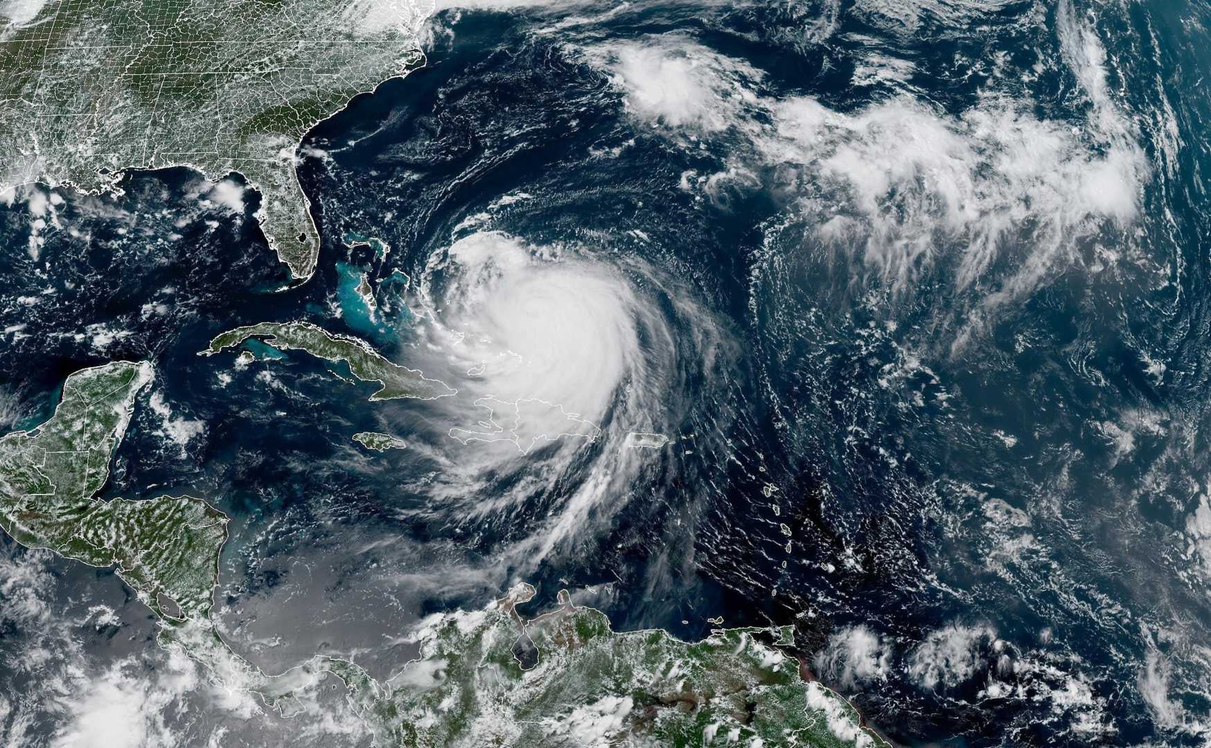
WASHINGTON, D.C. — Hurricane Erin is threatening the US East Coast with dangerous rip currents, destructive waves, and storm surge, particularly impacting North Carolina‘s Outer Banks, meteorologists warn.
The Category 3 hurricane intensified rapidly over the weekend but is not expected to make landfall. Instead, it will produce perilous surf conditions as it moves along the coastline. Bermuda is also under threat from Erin’s northward path.
Already, the effects are evident. At least 75 rescues from rip currents were recorded along the southern coast of North Carolina on Monday, according to officials in New Hanover County. In response, Wrightsville Beach has issued a no-swim advisory that will last through Friday.
A tropical storm watch is currently in effect from the middle of North Carolina’s coast up to Kitty Hawk and includes the Pamlico Sound. This means tropical-storm-force winds of 39 to 73 mph could arrive within 48 hours.
Dare and Hyde counties, which cover most of the Outer Banks, have declared local states of emergency and issued mandatory evacuations for Hatteras and Ocracoke islands. Tropical storm warnings are also active for the Turks and Caicos Islands and southeast Bahamas.
Erin’s outer bands have already caused significant damage, including flooding and power outages. Puerto Rico experienced severe flooding and power loss, along with the Bahamas feeling Erin’s impact.
The National Hurricane Center notes that a tropical wave following Erin has a 60% chance of turning into a tropical depression or storm within a week, which would be named Fernand. A separate disturbance near Africa has a low chance of developing but could change as it proceeds across the Atlantic.
As Erin continues to travel north, forecasters predict it will maintain its status as a major hurricane, remaining at Category 3 or higher through at least midweek. The storm is expected to impact coastal areas with large waves, dangerous currents, and flooding.
Extensive beach erosion in the Outer Banks is anticipated, with waves exceeding 20 feet expected this week, which could destroy protective dune structures. According to the National Park Service, these waves could lead to severe flooding inland.
This is not the first time the Outer Banks have faced such threats. Last year, Hurricane Ernesto caused multiple homes to collapse into the ocean. Currently, two homes in Rodanthe are considered at high risk of collapse due to Erin’s powerful waves, as noted by Cape Hatteras National Seashore Superintendent Dave Hallac.
On Wednesday and Thursday, normal tidal levels will peak, amplifying the flooding risks posed by Erin’s waves. Forecasters predict Bermuda will experience turbulent seas and possibly tropical storm winds later this week.
Erin’s rapid intensification is a stark reminder of escalating storm strength in a warming climate. Over the weekend, Erin increased from a tropical storm to a Category 5 hurricane, officially peaking at 160 mph. Hurricane-force winds extend up to 80 miles from the center, while tropical-storm-force winds spread up to 230 miles.
Despite colder waters beneath the surface, the hurricane remains powerful due to higher-than-normal sea surface temperatures, underscoring the unusual formation of a Category 5 storm early in the season.


