News
Hurricane Erin Weakens, New Storms Develop in Atlantic Ocean
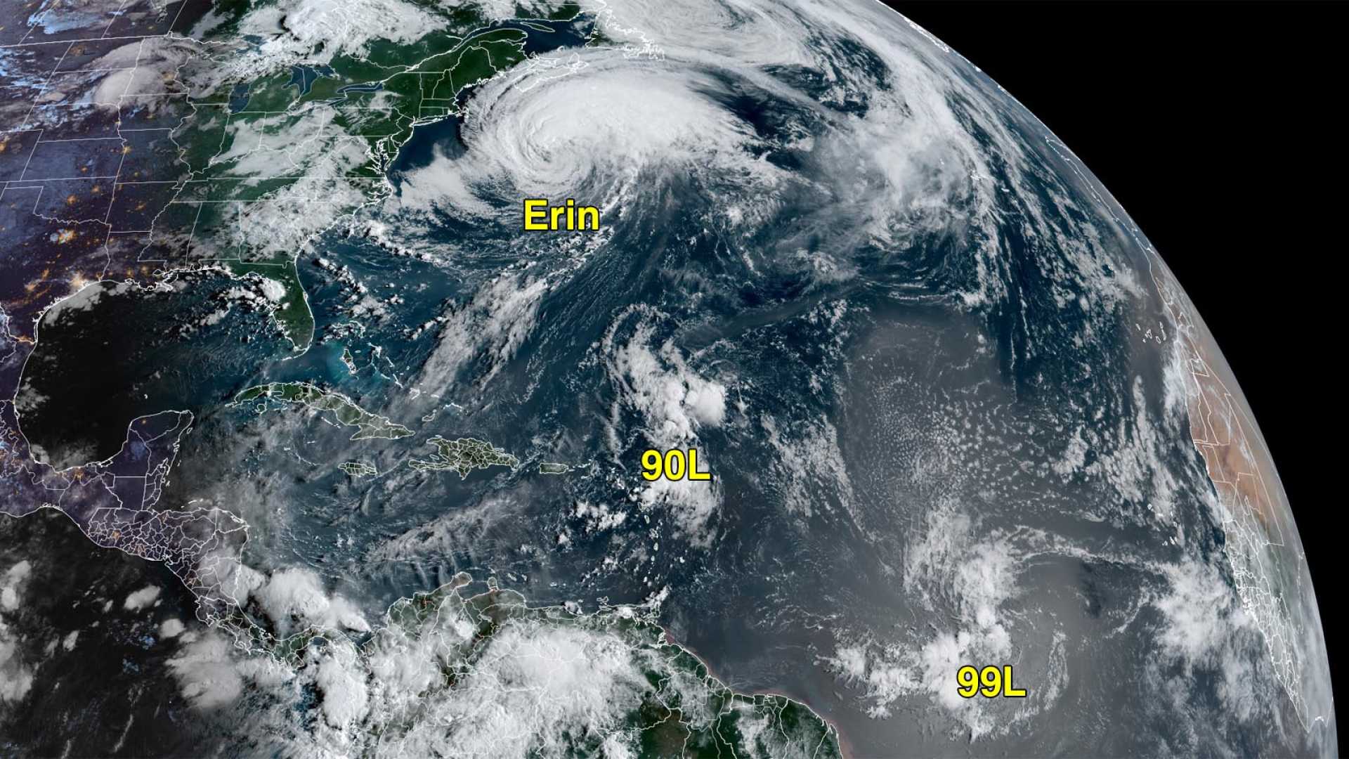
NEW ENGLAND, August 22, 2025 — Hurricane Erin continues to churn in the North Atlantic, remaining well southeast of New England. The storm’s large circulation, with tropical-storm-force winds extending 600-700 miles, is causing rip currents along parts of the U.S. East Coast, Bermuda, and Atlantic Canada. Erin is expected to be classified as a post-tropical cyclone by Friday night.
As of 8 a.m. EDT Friday, Erin was located about 400 miles from both Bermuda and Halifax, Nova Scotia. It boasts maximum sustained winds of 90 mph and is moving northeast at 22 mph. Although it is weakening into a mid-latitude storm, Erin’s winds might stay strong through the weekend.
Erin’s size and previous peak as a Category 5 storm are notable, as it has managed to complete its lifecycle without making landfall. Tragically, nine fatalities occurred in Cabo Verde from flooding linked to the storm’s initial disturbance shortly before Erin was identified as a tropical storm. An additional death was reported in the Dominican Republic.
“Of the nearly 350 Atlantic hurricanes over the last 60 years, fewer than 15 ever grew as large as Erin,” said Michael Lowry, a hurricane expert. “This places Erin in the top 4% of Atlantic hurricanes in terms of size.”
Coastal flooding associated with Erin was recorded on Thursday night, especially in Duck, North Carolina; Virginia City, Virginia; and Kiptopeke, Virginia. Nine other states including Maryland and New York experienced minor to moderate flooding.
Meanwhile, Invest 90L, another system in the Atlantic, is likely to develop into a tropical storm by early next week. Currently disorganized, it is moving northwest near the Leeward Islands with an 80% chance of formation over the next two days according to the National Hurricane Center.
The potential impact area for 90L includes Bermuda, as it may follow a route toward the island early next week. It is currently traveling over unusually warm waters, which may help its development.
A second system, Invest 99L, is also moving through the tropical Atlantic, though it is hampered by dry air and moderate wind shear. The National Hurricane Center gives it a 40% chance of formation in the next two days.
Residents in the Windward Islands and southern Leeward Islands are advised to monitor the progress of both systems as they may impact the region in the coming days.


